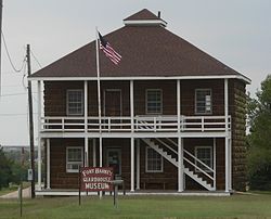
Fort Harker (Kansas)
|
Fort Harker
|
|

Fort Harker guardhouse
|
|
| Location | Kanopolis, Kansas, USA |
|---|---|
| Coordinates | 38°42′35″N 98°9′25″W / 38.70972°N 98.15694°WCoordinates: 38°42′35″N 98°9′25″W / 38.70972°N 98.15694°W |
| Built | 1866-1867 |
| NRHP Reference # | 72000497, 74000834 |
| Added to NRHP | 1972, 1974 |
Fort Harker, located in Kanopolis, Kansas, was an active military installation of the United States Army from November 17, 1866 to October 5, 1872. The fortification was named after General Charles Garrison Harker, who was killed in action at the Battle of Kennesaw Mountain in the American Civil War. Fort Harker replaced Fort Ellsworth, which had been located 1.6 km (0.99 mi) from the location of Fort Harker and was abandoned after the new fortifications at Fort Harker were constructed. Fort Harker was a major distribution point for all military points farther west and was one of the most important military stations west of the Missouri River.
Fort Ellsworth (see Fort Ellsworth (Kansas))was established in August, 1864 at the junction of the Fort Riley-Fort Larned Road and the Smoky Hill Trail, near the Smoky Hill River. Fort Ellsworth was established as the command headquarters for the District of the Upper Arkansas. Soldiers at the fort patrolled the overland trails to protect wagon trains from any resistance from the Native American tribes in the area. The fort also served an important role in distributing supplies to other United States Army outposts further west. Fort Ellsworth connected supply lines from Fort Leavenworth and Fort Riley to the east with Fort Zarah, Fort Larned, Fort Dodge (see Fort Dodge (US Army Post)), Fort Hays, and Fort Wallace to the west. After two years of rapid growth, the fort was badly in need of better facilities and more space.
...
Wikipedia

