Fort Belknap Agency, MT
| Fort Belknap Agency, Montana | |
|---|---|
| Census-designated place | |
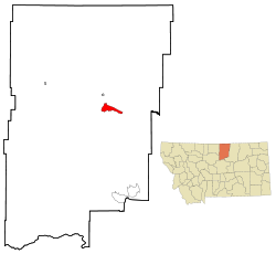
 Location of Fort Belknap Agency, Montana |
|
| Coordinates: 48°28′8″N 108°45′19″W / 48.46889°N 108.75528°WCoordinates: 48°28′8″N 108°45′19″W / 48.46889°N 108.75528°W | |
| Country | United States |
| State | Montana |
| County | Blaine |
| Area | |
| • Total | 45.8 sq mi (118.5 km2) |
| • Land | 45.5 sq mi (117.8 km2) |
| • Water | 0.3 sq mi (0.7 km2) |
| Elevation | 2,375 ft (724 m) |
| Population (2010) | |
| • Total | 1,293 |
| • Density | 28/sq mi (11.0/km2) |
| Time zone | Mountain (MST) (UTC-7) |
| • Summer (DST) | MDT (UTC-6) |
| Area code(s) | 406 |
| FIPS code | 30-27850 |
| GNIS feature ID | 0771503 |
Fort Belknap Agency is a census-designated place (CDP) in Blaine County, Montana, in the United States. As of the 2010 census, the CDP population was 1,293.
Fort Belknap Agency is the capital of the Fort Belknap Indian Reservation. It is located at the northern end of the reservation at the junction of U.S. Highway 2 and Montana Highway 66. The town is the home of Aaniiih Nakoda College, as well as other facilities such as the Fort Belknap Hospital, an office of the Bureau of Indian Affairs, the Fort Belknap Tribal Council and Tribal Police, and a highway rest area.
Fort Belknap Agency is located at 48°28′8″N 108°45′19″W / 48.46889°N 108.75528°W (48.468779, -108.755390).
According to the United States Census Bureau, the CDP has a total area of 45.8 square miles (118.5 km2), of which 45.5 square miles (117.8 km2) is land and 0.27 square miles (0.7 km2), or 0.56%, is water.
As of the census of 2000, there were 1,262 people, 345 households, and 287 families residing in the CDP. The population density was 116.4 people per square mile (45.0/km²). There were 380 housing units at an average density of 35.1/sq mi (13.5/km²). The racial makeup of the CDP was 2.61% White, 0.32% African American, 95.64% Native American, 0.08% Asian, 0.16% Pacific Islander, and 1.19% from two or more races. Hispanic or Latino of any race were 1.51% of the population.
...
Wikipedia
