Fort Bayard Historic District
|
Fort Bayard Historic District
|
|

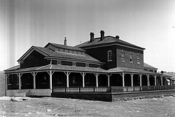
Fort Bayard Post Hospital, circa 1890
|
|
| Nearest city | Santa Clara, New Mexico |
|---|---|
| Coordinates | 32°47′47″N 108°8′56″W / 32.79639°N 108.14889°WCoordinates: 32°47′47″N 108°8′56″W / 32.79639°N 108.14889°W |
| Area | 704 acres (285 ha) |
| Built | 1866 |
| Architectural style | Classical Revival, Colonial Revival, et al. |
| NRHP Reference # | 02000726 |
| NMSRCP # | 1803 |
| Significant dates | |
| Added to NRHP | July 7, 2002 |
| Designated NHLD | March 19, 2004 |
| Designated NMSRCP | July 20, 2001 |
The Fort Bayard Historic District encompasses the area that was the location of Fort Bayard, a United States Army military installation north of present-day Santa Clara, New Mexico. Founded in 1866, the fort at first provided security (mainly by African-American "Buffalo Soldiers") against Native American attacks on settlers during the settlement of the region in the 19th century. It was then converted into the army's first tuberculosis sanitarium, and later became a VA hospital. The property is now the Fort Bayard Medical Center, a long-term nursing care facility operated by the state of New Mexico. The only surviving 19th-century elements of the fort are some of its landscaping, and the Fort Bayard National Cemetery. The site was designated a National Historic Landmark District in 2004.
Fort Bayard was established as a United States Army installation in 1866 to protect miners and other settlers in the area along the Apache Trail. The fort was named for Brigadier General George Dashiell Bayard, who was mortally wounded at the Battle of Fredericksburg in 1862. Fifteen square miles of land were set aside as the Fort Bayard Military Reservation by presidential order in 1869. In 1886, then-Second Lieutenant John Pershing arrived at Fort Bayard and oversaw the installation of a heliograph, linking the fort to an Army communications network from Arizona to Texas.
...
Wikipedia


