Fore-Balkan
| Balkan Mountains | |
|---|---|
| Stara Planina, Стара планина | |

A view from Kom Peak in western Bulgaria.
|
|
| Highest point | |
| Peak | Botev Peak |
| Elevation | 2,376 m (7,795 ft) |
| Coordinates | 42°43′00″N 24°55′04″E / 42.71667°N 24.91778°E |
| Dimensions | |
| Length | 530 km (330 mi) west-east |
| Width | 15–50 kilometres (9–31 mi) north-south |
| Area | 11,596 km2 (4,477 sq mi) |
| Geography | |
| Countries | Bulgaria and Serbia |
| Range coordinates | 43°15′N 25°0′E / 43.250°N 25.000°ECoordinates: 43°15′N 25°0′E / 43.250°N 25.000°E |
| Geology | |
| Type of rock | granite, gneiss, limestone |
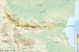
The Balkan mountain range (Bulgarian and Serbian Cyrillic: Стара планина, Latin Serbian Stara planina, "Old Mountain"; Bulgarian pronunciation: [ˈstarɐ pɫɐniˈna]; Serbian pronunciation: [stâːraː planǐna]) is a mountain range in the eastern part of the Balkan Peninsula. The Balkan range runs 560 km from the Vrashka Chuka Peak on the border between Bulgaria and Serbia eastward through central Bulgaria to Cape Emine on the Black Sea. The highest peaks of the Balkan Mountains are in central Bulgaria. The highest peak is Botev at 2,376 m, which makes the mountain range the third highest in the country, after Rila and Pirin. The mountains are the source of the name of the Balkan Peninsula.
The mountain range forms the watershed between the Black Sea and Aegean Sea catchment areas, with the exception of an area in west, where it is crossed by the spectacular Iskar Gorge. The karst relief determines the large number of caves, including Magura, featuring the most important and extended European post-Palaeolithic cave painting, Ledenika, Saeva dupka, Bacho Kiro, etc. The most notable rock formation are the Belogradchik Rocks in the west.
...
Wikipedia

