Florissant Fossil Beds National Monument
| Florissant Fossil Beds National Monument | |
|---|---|
|
IUCN category III (natural monument or feature)
|
|

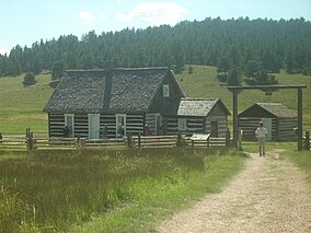
The Pioneer House, showing how the original pioneers of the west lived
|
|
| Location | Teller County, Colorado, United States |
| Nearest city | Florissant, Colorado |
| Coordinates | 38°54′49″N 105°17′11″W / 38.91374°N 105.28627°WCoordinates: 38°54′49″N 105°17′11″W / 38.91374°N 105.28627°W |
| Area | 5,998 acres (24.27 km2) |
| Authorized | August 20, 1969 |
| Visitors | 61,289 (in 2011) |
| Governing body | National Park Service |
| Website | Florissant Fossil Beds National Monument |
The Florissant Fossil Beds National Monument is a national monument located in Teller County, Colorado. The location is famous for the abundant and exceptionally preserved insect and plant fossils that are found in the mudstones and shales of the Florissant Formation. Based on argon radiometric dating, the formation is Eocene (approximately 34 million years old ) in age and has been interpreted as a lake environment. The fossils have been preserved because of the interaction of the volcanic ash from the nearby Thirtynine Mile volcanic field with diatoms in the lake, causing an diatom bloom. As the diatoms fell to the bottom of the lake, any plants or animals that had recently died were preserved by the diatom falls. Fine layers of clays and muds interspersed with layers of ash form "paper shales" holding beautifully-preserved fossils.
The name Florissant comes from the French word for flowering. In the late 19th century tourist and excavators came to this location to observe the wildlife and collect samples for collections and study. The Petrified Forest, that is now one of the main attractions at the monument today, lost much of its mass due to collectors removing large amounts of petrified wood from the site. During the 1860s and 1870s the area was mapped by geologists for the first time. Paleontologists followed soon after to collect fossils for research. In 1969, the Florissant Fossil Bed National Monument was established after a long legal battle between local land owners and the federal government. Today, the park receives approximately 60,000 visitors a year, and is the site of ongoing paleontological investigations.
In the late Eocene to early Oligocene, approximately 34 million years ago, the area was a lake environment with redwood trees. The basement is the Proterozoic aged Pikes Peak Granite. There is an unconformity from the Pikes Peak Granite to the next unit, the Wall Mountain tuff. The massive unconformity is due to erosion that occurred during the uplift of the modern Rocky Mountains, the Laramide Orogeny. The Wall Mountain Tuff was deposited as a result of a large eruption from a distant caldera. The Florissant Formation itself is composed of alternating units of shale, mudstone, conglomerate, and volcanic deposits. There are six described units within the Florissant Formation: the lower shale unit, lower mudstone unit, middle shale unit, caprock conglomerate unit, upper shale unit, and the upper pumice unit. Each of the shale units represents lacustrine environments, composed of very thin shales that are abundant in fossils, which alternate with tuffs from eruptions. The lower mudstone has been interpreted as a stream environment with the top of the unit being a lahar deposit. The mudstones were deposited on a valley floor, but not in a lake. The separation of the shale units by non-lake deposits could mean that there were two generations of lake deposits. Lahars that went through the valley could have dammed up the valley, allowing for the creation of a lake. The middle and upper shale units were then deposited in this second generation of the lake. The caprock conglomerate was deposited as a large lahar went through the valley and accumulated down on the lake floor.
...
Wikipedia


