Flintville, Tennessee
| Flintville, Tennessee | |
|---|---|
| Census-designated place | |

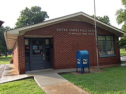
Flintville Post office
|
|
 Location in Lincoln County and the state of Tennessee. |
|
| Coordinates: 35°03′45″N 86°25′11″W / 35.06250°N 86.41972°WCoordinates: 35°03′45″N 86°25′11″W / 35.06250°N 86.41972°W | |
| Country | United States |
| State | Tennessee |
| County | Lincoln |
| Area | |
| • Total | 5.323 sq mi (13.79 km2) |
| • Land | 5.323 sq mi (13.79 km2) |
| • Water | 0 sq mi (0 km2) |
| Elevation | 902 ft (275 m) |
| Population (2010) | |
| • Total | 627 |
| • Density | 120/sq mi (45/km2) |
| Time zone | Central (CST) (UTC-6) |
| • Summer (DST) | CDT (UTC-5) |
| ZIP code | 37335 |
| Area code(s) | 931 |
| GNIS feature ID | 1284492 |
Flintville is an unincorporated community and census-designated place (CDP) in Lincoln County, Tennessee, United States. As of the 2010 census, its population was 627. Flintville is located along Tennessee State Route 275 10.5 miles (16.9 km) southeast of Fayetteville. Flintville has a post office with ZIP code 37335, which opened on February 16, 1861.
...
Wikipedia
