Flinders Council
|
Flinders Council Tasmania |
|||||||||||||
|---|---|---|---|---|---|---|---|---|---|---|---|---|---|

Flinders Council
|
|||||||||||||
| Coordinates | 40°0′36″S 148°03′0″E / 40.01000°S 148.05000°ECoordinates: 40°0′36″S 148°03′0″E / 40.01000°S 148.05000°E | ||||||||||||
| Population | 783 (2015 est.) | ||||||||||||
| • Density | 0.38377/km2 (0.9940/sq mi) | ||||||||||||
| Area | 2,040.3 km2 (787.8 sq mi) | ||||||||||||
| Mayor | Carol Cox | ||||||||||||
| Council seat | Whitemark | ||||||||||||
| Region | Furneaux Group and surrounding island groups | ||||||||||||
| State electorate(s) | Bass | ||||||||||||
| Federal Division(s) | Bass | ||||||||||||
 |
|||||||||||||
| Website | Flinders Council | ||||||||||||
|
|||||||||||||
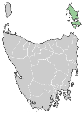
Flinders Council is a local government area of Tasmania. It covers more than 60 islands off the north-eastern tip of Tasmania at the eastern end of Bass Strait. Of these 60, 12 have permanent populations. The bigger ones are Clarke Island, Cape Barren Island, and the largest and most populous, Flinders Island. The Flinders Council includes the Furneaux Group together with the groups of islands to the north west Kent Group, Hogan Island Group, Curtis Group, Wilsons Promontory Islands (only Tasmanian part).
...
Wikipedia
