Flims, Switzerland
| Flims | ||
|---|---|---|

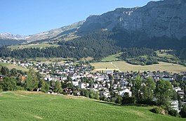
Flims Dorf under "Flimserstein"
|
||
|
||
| Coordinates: 46°50′N 9°17′E / 46.833°N 9.283°ECoordinates: 46°50′N 9°17′E / 46.833°N 9.283°E | ||
| Country | Switzerland | |
| Canton | Graubünden | |
| District | Imboden | |
| Area | ||
| • Total | 50.51 km2 (19.50 sq mi) | |
| Elevation | 1,081 m (3,547 ft) | |
| Population (Dec 2015) | ||
| • Total | 2,697 | |
| • Density | 53/km2 (140/sq mi) | |
| Postal code | 7017-7019 | |
| SFOS number | 3732 | |
| Surrounded by | Glarus Süd (GL), Laax, Pfäfers (SG), Sagogn, Trin, Valendas, Versam | |
| Website |
www SFSO statistics |
|
Flims (Romansh: Flem) is a municipality in the Imboden Region in the Swiss canton of Graubünden. The town of Flims is dominated by the Flimserstein which you can see from almost anywhere in the area.
Flims consists of the village of Flims (called Flims Dorf) and the hamlets of Fidaz and Scheia as well as Flims-Waldhaus, the initial birthplace of tourism in Flims, where most of the hotels were built before and after around 1900.
Flims has an area of 50.5 km2 (19.5 sq mi). Of this area, 33.7% is used for agricultural purposes, while 28.9% is forested. Of the rest of the land, 3.6% is settled (buildings or roads) and the remainder (33.9%) is non-productive (rivers, glaciers or mountains).
Before 2017, the municipality was located in the Trin sub-district, of the Imboden district, after 2017 it was part of the Imboden Region. Flims is located on a terrace north of the Rhine valley, forming the Ruinaulta gorge here. The country-side has numerous streams and lakes north of the village, from which the name derives; "fluminae" in Latin means "many streams". The main river is called Flem while Caumasee and Crestasee to the south of the town do not have tributaries for lying in the debris area of prehistoric Flims Rockslide, where the landscape is very rough and completely forested as there was no agriculture possible ever.
The lowest point of the municipality is at the Rhine river in the Ruinaulta at 630 meters, while Piz Segnas reaches 3099 m. Both Piz Segnas and neighbouring Piz Dolf show the line of the Glarus thrust in its upper part, now a UNESCO world heritage. The easiest access to the area is an aerial cableway to Fil de Cassons from Flims or any of various hikes to this ridge lying southeast of Piz Dolf. One route uses the ascent via Val Bargis, a wild valley running around Flimserstein.
...
Wikipedia


