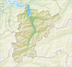
Flüelen
| Flüelen | ||
|---|---|---|
 |
||
|
||
| Coordinates: 46°54′N 8°37′E / 46.900°N 8.617°ECoordinates: 46°54′N 8°37′E / 46.900°N 8.617°E | ||
| Country | Switzerland | |
| Canton | Uri | |
| District | n.a. | |
| Area | ||
| • Total | 12.42 km2 (4.80 sq mi) | |
| Elevation | 435 m (1,427 ft) | |
| Population (Dec 2015) | ||
| • Total | 1,972 | |
| • Density | 160/km2 (410/sq mi) | |
| Postal code | 6454 | |
| SFOS number | 1207 | |
| Surrounded by | Altdorf, Bauen, Bürglen, Isenthal, Seedorf, Sisikon | |
| Website |
www SFSO statistics |
|
Flüelen is a municipality in the canton of Uri in Switzerland.
Flüelen is first mentioned in 1266 as Vluolon.
Flüelen formed an important transshipment point on Switzerland's transport system for many centuries, and at least since the opening of the first track across the Gotthard Pass in 1230. The various routes across the pass reached Lake Lucerne at Flüelen, and until the latter half of the 19th century the lake provided the best onward link to the cities of northern Switzerland. In the 13th century the Castle of Rudenz was built in Flüelen as an Imperial customs post to collect customs fees from the Gotthard traffic.
In 1906, the Altdorf–Flüelen tramway was constructed to connect the centre of Altdorf with Fluelen railway station. The electric tramway operated until 1951, when it was replaced by a bus service.
Flüelen has an area, (as of the 2004/09 survey) of 12.42 km2 (4.80 sq mi). Of this area, about 23.9% is used for agricultural purposes, while 58.1% is forested. Of the rest of the land, 6.4% is settled (buildings or roads) and 11.6% is unproductive land. In the 2004/09 survey a total of 45 ha (110 acres) or about 3.6% of the total area was covered with buildings, an increase of 7 ha (17 acres) over the 1981/85 amount. Over the same time period, the amount of recreational space in the municipality increased by 2 ha (4.9 acres) and is now about 0.56% of the total area. Of the agricultural land 90 ha (220 acres) is fields and grasslands and 285 ha (700 acres) consists of alpine grazing areas. Since 1981/85 the amount of agricultural land has decreased by 16 ha (40 acres). Over the same time period the amount of forested land has increased by 7 ha (17 acres). Rivers and lakes cover 9 ha (22 acres) in the municipality.
The municipality is located along Lake Lucerne. It developed as a transshipment point on the trade routes over the Gotthard pass and along the lake. It consists of the village of Flüelen, the outer village settlements and scattered farm houses in the valley and up the mountain sides.
...
Wikipedia


