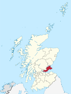
Fife, Scotland
| Fife Fife Fìobha |
||
|---|---|---|
 |
||
|
||
| Coordinates: 56°15′00″N 3°12′00″W / 56.25000°N 3.20000°WCoordinates: 56°15′00″N 3°12′00″W / 56.25000°N 3.20000°W | ||
| Admin HQ |
Glenrothes (formerly Cupar) |
|
| Government | ||
| • Body | Fife Council | |
| • Control | Labour minority (council NOC) | |
| • MPs |
Douglas Chapman Stephen Gethins Peter Grant Roger Mullin |
|
| • MSPs |
Annabelle Ewing Jenny Gilruth Willie Rennie Shirley-Anne Somerville David Torrance |
|
| Area | ||
| • Total | 512 sq mi (1,325 km2) | |
| Area rank | Ranked 13th | |
| Population (mid-2015 est.) | ||
| • Total | 368,100 | |
| • Rank | Ranked 3rd | |
| • Density | 720/sq mi (277/km2) | |
| ONS code | S12000015 | |
| ISO 3166 code | GB-FIF | |
| Website | http://www.fife.gov.uk/ | |
Fife ([ˈfəif]; Scottish Gaelic: Fìobha) is a council area and historic county of Scotland. It is situated between the Firth of Tay and the Firth of Forth, with inland boundaries to Perth and Kinross and Clackmannanshire. By custom it is widely held to have been one of the major Pictish kingdoms, known as Fib, and is still commonly known as the Kingdom of Fife within Scotland.
It is a lieutenancy area, and was a county of Scotland until 1975. It was very occasionally known by the anglicisation Fifeshire in old documents and maps compiled by English cartographers and authors. A person from Fife is known as a Fifer.
Fife was a local government region divided into three districts: Dunfermline, Kirkcaldy and North-East Fife. Since 1996 the functions of the district councils have been exercised by the unitary Fife Council.
...
Wikipedia

