Kirkcaldy
Kirkcaldy
|
|
|---|---|
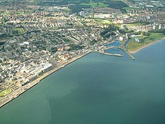
 Aerial view of Kirkcaldy and its waterfront |
|
| Kirkcaldy shown within Fife | |
| Area | 6.9 sq mi (18 km2) |
| Population | 49,460 |
| • Density | 1,669/sq mi (644/km2) |
| OS grid reference | NT275915 |
| • Edinburgh | 11 miles (18 kilometres) S |
| • London | 341 miles (549 kilometres) SSE |
| Civil parish | |
| Council area | |
| Lieutenancy area | |
| Country | Scotland |
| Sovereign state | United Kingdom |
| Post town | KIRKCALDY |
| Postcode district | KY1, KY2 |
| Dialling code | 01592 |
| Police | Scottish |
| Fire | Scottish |
| Ambulance | Scottish |
| EU Parliament | Scotland |
| UK Parliament | |
| Scottish Parliament | |
Kirkcaldy (![]() i/kərˈkɔːdi/; Scottish Gaelic: Cair Chaladain) is a town and former royal burgh in Fife, on the east coast of Scotland. It is about 11.6 miles (19 km) north of Edinburgh and 27.6 miles (44 km) south-southwest of Dundee. The town had a population of 49,460, which was recorded in 2011, making it Fife's second-largest settlement and the 11th most populous settlement in Scotland.
i/kərˈkɔːdi/; Scottish Gaelic: Cair Chaladain) is a town and former royal burgh in Fife, on the east coast of Scotland. It is about 11.6 miles (19 km) north of Edinburgh and 27.6 miles (44 km) south-southwest of Dundee. The town had a population of 49,460, which was recorded in 2011, making it Fife's second-largest settlement and the 11th most populous settlement in Scotland.
Kirkcaldy has long been nicknamed the Lang Toun (![]() listen ; Scots for "long town") in reference to the early town's 0.9-mile (1.4 km) main street, as indicated on maps of the 16th and 17th centuries. The street later reached a length of nearly 4 miles (6.4 km), connecting the burgh to the neighbouring settlements of Linktown, Pathhead, Sinclairtown and Gallatown, which became part of the town in 1876. The formerly separate burgh of Dysart was merged into Kirkcaldy in 1930.
listen ; Scots for "long town") in reference to the early town's 0.9-mile (1.4 km) main street, as indicated on maps of the 16th and 17th centuries. The street later reached a length of nearly 4 miles (6.4 km), connecting the burgh to the neighbouring settlements of Linktown, Pathhead, Sinclairtown and Gallatown, which became part of the town in 1876. The formerly separate burgh of Dysart was merged into Kirkcaldy in 1930.
...
Wikipedia

