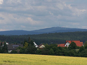
Fichtel Mountains
| Fichtel Mountains (Fichtelgebirge) |
|
|---|---|

|
|
| Highest point | |
| Peak | Schneeberg |
| Elevation | 1,051 m (3,448 ft) |
| Geography | |
| State | Bavaria & Czech Republic |
| Range coordinates | 50°03′N 11°51′E / 50.05°N 11.85°ECoordinates: 50°03′N 11°51′E / 50.05°N 11.85°E |
| Parent range | Thuringian-Franconian Highlands |
The Fichtel Mountains (German: Fichtelgebirge, Czech: Smrčiny), form a small horseshoe-shaped mountain range in northeastern Bavaria, Germany. They extend from the valley of the Red Main River to the Czech border, a few foothills spilling over into the Czech Republic. They continue in a northeasterly direction as the Ore Mountains, and in a southeasterly direction as the Bohemian Forest. The Fichtel Mountains contain an important nature park, the Fichtel Mountain Nature Park, with an area of 1,020 square kilometres (390 sq mi).
The first person to write about the Fichtel Mountains, Matthias of Kemnath (actually Matthias Widmann, b 23 February 1429 in Kemnath) reported in 1476: Ein bergk, hoch, weitt, wolbekant ligt in Beiern, gnant der Fichtelberg ("A mountain, high, wide and well-known, lies in Bavaria, known as the Fichtelberg"). In descriptions of the border in 1499 and 1536, the mountain that is now called the Ochsenkopf was called Vichtelberg; thereafter the name was extended to the whole mountain region. It is also mentioned in old documents: around 1317 the lords of Hirschberg were enfeoffed inter alia with the walt zu dem Vythenberge. By the 14th century iron ore was being extracted in the St. Veith Pit on the southern foot of the mountain. Vyth → Veit → Fichtel. High-profile local history and name researchers have still not had the last word.
Together with the Thuringian Forest, Thuringian Highland and Franconian Forest the Fichtel forms a major natural region called the Thuringian-Franconian Highlands (no. D48 and 39).
...
Wikipedia

