Feteiras
| Feteiras | |
| Civil Parish | |
|
The coastal plain of Feteiras, with its surroundings of pasturelands and subdivided parecels
|
|
| Official name: Freguesia das Feteiras | |
| Name origin: Portuguese for places of many ferns | |
| Country | |
|---|---|
| Autonomous Region | |
| Island | São Miguel |
| Municipality | Ponta Delgada |
| Localities | Biscoito, Chã do Tanque, Feteiras |
| Center | Cerrado da Fonte de Cima |
| - elevation | 406 m (1,332 ft) |
| - coordinates | 37°48′58″N 25°46′31″W / 37.81611°N 25.77528°WCoordinates: 37°48′58″N 25°46′31″W / 37.81611°N 25.77528°W |
| Highest point | Éguas |
| - location | Sete Cidades Massif |
| - elevation | 873 m (2,864 ft) |
| - coordinates | 37°49′37″N 25°45′17″W / 37.82694°N 25.75472°W |
| Area | 23.53 km2 (9 sq mi) |
| - water | .05 km2 (0 sq mi) |
| - urban | .52 km2 (0 sq mi) |
| Population | 1,571 (2011) |
| Density | 67/km2 (174/sq mi) |
| LAU | Junta Freguesia |
| - location | Largo da Igreja |
| President Junta | João Manuel Raposo Barbosa |
| Timezone | Azores (UTC-1) |
| - summer (DST) | Azores (UTC0) |
| Postal Zone | 9500-554 |
| Area Code & Prefix | (+351) 292 XXX-XXXX |
| Demonym | Feteirense |
| Patron Saint | Santa Luzia |
|
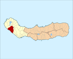
Location of the civil parish of Feteiras in the municipality of Ponta Delgada
|
|
| Statistics: Instituto Nacional de Estatística | |
| Geographic detail from CAOP (2010) produced by Instituto Geográfico Português (IGP) | |
Feteiras is a civil parish in the municipality of Ponta Delgada in the Portuguese archipelago of the Azores. It is situated in the western part of the island of São Miguel, on the south coast. The population in 2011 was 1,571, in an area of 23.53 square kilometres (9.08 sq mi).
In the 16th century, the coastal area around the Porto dos Batéis (a name derived from the construction of a great carrack in the locale), was the principal settlement. This lowland region was eventually abandoned and settlers began populating the highland region above the cliffs, extending along the roadway that developed.
Father Lopez da Luz, writing in the Revista Micaelense, noted that the beginnings of settlement in this region, occurred half a century after the island's settlement.Gaspar Frutuoso, writing in Saudades da Terra indicated that it obtained the name Feteiras for the pasturelands of ferns that grew in the pasturelands. Has he noted:
By royal charter, from King Manuel I Feteiras was de-annexed from the jurisdiction of Vila Franca do Campo and integrated into the municipality of Ponta Delgada. By the end of the 15th century, Father Lopes da Luz, indicated that the parish of Santa Luzia das Feteiras had already existed for some time. Ironically, though, the parish church was dedicated to Our Lady of Guadalupe (Portuguese: Igreja de Nossa Senhora de Guadalupe), and was the parish seat, since the original church to Santa Luzia was in ruin by the end of the 16th century.
By the beginning of the 19th century, the estimated population of 860 people of the parish, was supported by the remodelled and expanded church of Nossa Senhora da Guadalupe, which was rechristened to Santa Luzia. The older image from the abandoned church was quickly transported to the new church, and placed in one of the altars. By the beginning of the 20th century, the population had surpassed 1000 residents.
Feteiras is situated along the southern coast of the island, extending into the interior, with its highest point being along the Sete Cidades Massif in area of Fonte da Serra, at junction of various parishes including Sete Cidades, Santo António and Capelas. In addition to these parishes, Feteiras is bounded on the east by Relva and west by Candelária and connected by the regional E.R.1-1ª roadway to the island centre of Ponta Delgada, some 15 kilometres (9.3 mi) to the east.
...
Wikipedia


