Ferwerderadeel
|
Ferwerderadiel Ferwerderadeel |
|||
|---|---|---|---|
| Municipality | |||

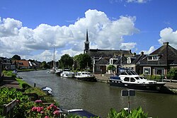
Canal through Burdaard
|
|||
|
|||
 Location in Friesland |
|||
| Coordinates: 53°20′N 5°50′E / 53.333°N 5.833°ECoordinates: 53°20′N 5°50′E / 53.333°N 5.833°E | |||
| Country | Netherlands | ||
| Province | Friesland | ||
| Government | |||
| • Body | Municipal council | ||
| • Mayor | Wil van den Berg (CDA) | ||
| Area | |||
| • Total | 133.18 km2 (51.42 sq mi) | ||
| • Land | 97.71 km2 (37.73 sq mi) | ||
| • Water | 35.47 km2 (13.70 sq mi) | ||
| Elevation | 1 m (3 ft) | ||
| Population (February 2017) | |||
| • Total | 8,755 | ||
| • Density | 90/km2 (200/sq mi) | ||
| Time zone | CET (UTC+1) | ||
| • Summer (DST) | CEST (UTC+2) | ||
| Postcode | 9070–9179 | ||
| Area code | 0518, 0519, 058 | ||
| Website | www |
||
Ferwerderadiel (![]() pronunciation ) is a municipality of Friesland in the northern Netherlands. Its official name is West Frisian. The Dutch name is Ferwerderadeel.
pronunciation ) is a municipality of Friesland in the northern Netherlands. Its official name is West Frisian. The Dutch name is Ferwerderadeel.
Bartlehiem, Blije, Burdaard, Ferwert, Ginnum, Hallum, Hegebeintum, Jannum, Jislum, Lichtaard, Marrum, Reitsum, Wânswert, Westernijtsjerk.
'Dutch topographic map of the municipality of Ferwerderadiel, June 2015
Birdaard, drawbridge and church
...
Wikipedia


