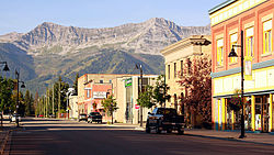
Fernie, British Columbia
| Fernie | ||
|---|---|---|
| City | ||
| The Corporation of the City of Fernie | ||

Downtown Fernie, looking south
|
||
|
||
| Motto: "In montibus ad flumen" (Latin) "In the mountains by the river" |
||
| Location of Fernie in British Columbia | ||
| Coordinates: 49°30′15″N 115°03′46″W / 49.50417°N 115.06278°WCoordinates: 49°30′15″N 115°03′46″W / 49.50417°N 115.06278°W | ||
| Country |
|
|
| Province |
|
|
| Region | Elk Valley/East Kootenay | |
| Regional District | Regional District of East Kootenay (RDEK) | |
| Established | 1904 | |
| Government | ||
| • City Mayor | Mary Giuliano | |
| • Governing body | Fernie City Council | |
| • MP | Wayne Stetski | |
| • MLA | Bill Bennett | |
| Area | ||
| • City | 13.50 km2 (5.21 sq mi) | |
| Elevation | 1,010 m (3,314 ft) | |
| Population (2016) | ||
| • City | 5,249 Ranked 692nd |
|
| • Metro | 7,192 | |
| Time zone | Mountain Standard (MST) (UTC-7) | |
| • Summer (DST) | Mountain Daylight (MDT) (UTC-6) | |
| Postal code span | V0B 1M(0–6) | |
| Area code(s) | 250 / 778 / 236 | |
| Highways |
|
|
| Website | Fernie Travel & Tourism | |
Fernie is a city in the Elk Valley area of the East Kootenay region of southeastern British Columbia, Canada, located on BC Highway 3 on the eastern approaches to the Crowsnest Pass through the Rocky Mountains. Founded in 1898 and incorporated as the City of Fernie in July 1904, the municipality has a population of over 5,000 with an additional 2,000 outside city limits in communities under the jurisdiction of the Regional District of East Kootenay. A substantial seasonal population swells the city during the winter months.
Fernie lies on the Elk River, along Canada's southernmost east-west transportation corridor through the Rockies that crosses the range via the Crowsnest Pass, 40 kilometres (25 mi) to the east. As the largest and longest-established community between Cranbrook and Lethbridge, Fernie serves as a minor regional centre, particularly for its fellow Elk Valley communities.
Fernie is the only city-class municipality in Canada that is fully encircled by the Rocky Mountains. The townsite was laid out in the crook of a doglegged glacial valley that today is drained by the Elk River. Three tributaries of the Elk—Coal, Lizard, and Fairy Creeks—rise in its side valleys and join the Elk either within or in close proximity to the townsite.
...
Wikipedia


