Fernandópolis
| Fernandópolis | |||
|---|---|---|---|
| Municipality | |||
|
|||
 Location in São Paulo state |
|||
| Location in Brazil | |||
| Coordinates: 20°17′02″S 50°14′47″W / 20.28389°S 50.24639°WCoordinates: 20°17′02″S 50°14′47″W / 20.28389°S 50.24639°W | |||
| Country |
|
||
| Region | Southeast Region | ||
| State | São Paulo | ||
| Mesoregion | São José do Rio Preto | ||
| Microregion | Fernandópolis | ||
| Government | |||
| • Mayor | Ana Maria Matoso Bim | ||
| Area | |||
| • Total | 550 km2 (210 sq mi) | ||
| Elevation | 535 m (1,755 ft) | ||
| Population (2015) | |||
| • Total | 68,120 | ||
| • Density | 120/km2 (320/sq mi) | ||
| Time zone | BRT/BRST (UTC-3/-2) | ||
| Postal code | 15600-000 | ||
| Area code | +55 17 | ||
| Website | www |
||
Fernandópolis is a municipality in the state of São Paulo, Brazil. The population is 68,120 (2015 est.) in an area of 550 km². Fernandópolis is the center of the microregion of Fernandópolis with 104,623 inhabitants and area of 2,811.7 km².
The beginning of the city has relation with the cattle creation in the region and the opening of a "cow road" (Estrada Boiadeira) in the beginning of the 20th century. The coffee production in the region begins in 1917.
In November 30, 1944, the district was established and in January 1, 1945 the municipality of Fernandópolis was officially established with the emancipation from Tanabi.
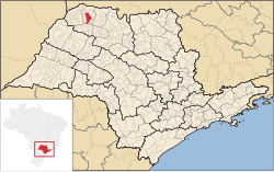
Fernandópolis is located in the northwest of São Paulo state, 555 km from the city of São Paulo.
The Tertiary sector is the economic basis of Fernandópolis. Commerce, services and public administration corresponds to 69.6% of the city GDP. Industry is 26.7% of the GDP, and the Primary sector corresponds to 3.6%.
The city hosts an annual Expo, the Exposição de Fernandópolis, with Rodeo and other leisure options.
All indicators are from SEADE and IBGE
The city has a professional football team, the Fernandópolis Futebol Clube.
...
Wikipedia


