Felmingham
| Felmingham | |
|---|---|
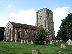
 St Andrew's church, Felmingham |
|
| Felmingham shown within Norfolk | |
| Area | 7.68 km2 (2.97 sq mi) |
| Population | 561 |
| • Density | 73/km2 (190/sq mi) |
| OS grid reference | TG251293 |
| Civil parish |
|
| District | |
| Shire county | |
| Region | |
| Country | England |
| Sovereign state | United Kingdom |
| Post town | NORTH WALSHAM |
| Postcode district | NR28 |
| Police | Norfolk |
| Fire | Norfolk |
| Ambulance | East of England |
| EU Parliament | East of England |
Felmingham is a village and civil parish in the English county of Norfolk. It covers an area of 7.68 km2 (2.97 sq mi) and had a population of 564 in 218 households as of the 2001 census, reducing slightly to 561 at the 2011 Census. For the purposes of local government, it falls within the district of North Norfolk.
The village is 2.3 miles (3.7 km) west of North Walsham, 4.3 miles (6.9 km) east of Aylsham and 16.4 miles (26.4 km) north of the city of Norwich. The River Bure passes very close to the eastern side of the village. The Parish of Felmingham and its council is responsible to the council of the District of North Norfolk and that of the County of Norfolk in which it is located.
A Roman temple hoard from Felmingham Hall near the village was acquired by the British Museum in 1925.
The village’s closest rail link is at nearby North Walsham Railway station where the Bittern Line from Cromer to Norwich can be accessed and the national rail network beyond. The village is sited along the B1145 a route which runs between King's Lynn and Mundesley, and is located between the A149 King’s Lynn to Great Yarmouth road (East of the Village) and the A140 Cromer to Norwich road (To the west). The nearest airport is at Norwich.
...
Wikipedia

