Fayette, MO
| City of Fayette, Missouri | |
|---|---|
| City | |

Town Square in Fayette
|
|
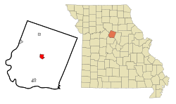
 Location in the state of Missouri |
|
| Coordinates: 39°8′44″N 92°41′10″W / 39.14556°N 92.68611°WCoordinates: 39°8′44″N 92°41′10″W / 39.14556°N 92.68611°W | |
| Country | United States |
| State | Missouri |
| County | Howard |
| Founded | 1823 |
| Government | |
| • Mayor | Kenneth O'Brian |
| • Administrator | Robin Triplett |
| Area | |
| • Total | 2.26 sq mi (5.85 km2) |
| • Land | 2.22 sq mi (5.75 km2) |
| • Water | 0.04 sq mi (0.10 km2) |
| Elevation | 699 ft (213 m) |
| Population (2010) | |
| • Total | 2,688 |
| • Estimate (2012) | 2,709 |
| • Density | 1,210.8/sq mi (467.5/km2) |
| Time zone | CST (UTC-6) |
| • Summer (DST) | CDT (UTC-5) |
| ZIP code | 65248 |
| Area code(s) | 660 |
| FIPS code | 29-23842 |
| GNIS feature ID | 0717869 |
| Website | http://fayette.missouri.org/ |
Fayette is a city in Howard County, Missouri, United States. The population was 2,688 at the 2010 census. It is the county seat of Howard County. It is part of the Columbia, Missouri Metropolitan Statistical Area.
Fayette was laid out in 1823. The community was named after Gilbert du Motier, Marquis de Lafayette. A post office has been in operation at Fayette since 1824.
The Edwin and Nora Payne Bedford House, Central Methodist College Campus Historic District, Coleman Hall, Fayette City Park Swimming Pool, Fayette Courthouse Square Historic District, Fayette Residential Historic District, Greenwood, Prior Jackson Homeplace, Alfred W. Morrison House, Oakwood, St. Mary's Episcopal Church, South Main Street Historic District, and Dr. Uriel S. Wright Office are listed on the National Register of Historic Places.
...
Wikipedia
