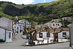
Fajãzinha
| Fajãzinha | |
| Civil Parish | |
|
The central square of Fajãzinha, with the Church of Nossa Senhora dos Remédios along the roadway, and the Ladeira do Picado in the background
|
|
| Official name: Freguesia da Fajãzinha | |
| Name origin: Portuguese for small debris field | |
| Country | |
|---|---|
| Region | |
| Island | Flores |
| Municipality | Lajes das Flores |
| Localities | Fajãzinha, Ladeiras |
| Landmark | Nossa Senhora dos Remédios |
| Center | Fajãzinha |
| - elevation | 90 m (295 ft) |
| - coordinates | 39°26′1″N 31°15′9″W / 39.43361°N 31.25250°WCoordinates: 39°26′1″N 31°15′9″W / 39.43361°N 31.25250°W |
| Highest point | Cova da Pedra |
| - location | Marcela |
| - elevation | 768 m (2,520 ft) |
| - coordinates | 39°25′27″N 31°13′25″W / 39.42417°N 31.22361°W |
| Lowest point | Sea level |
| - location | Atlantic Ocean |
| - elevation | 0 m (0 ft) |
| Area | 6.16 km2 (2 sq mi) |
| - urban | .011 km2 (0 sq mi) |
| Population | 76 (2011) |
| Density | 12/km2 (31/sq mi) |
| Settlement | fl.1676 |
| - Parish | c.July 1676 |
| - Civil parish | 28 November 1684 |
| LAU | Junta Freguesia |
| - location | Rua Nossa Senhora do Rosário |
| - coordinates | 39°25′57″N 31°15′13″W / 39.43250°N 31.25361°W |
| President Junta |
Paulo Eduardo Avelar Rodrigues |
| President Assembleia |
Ilda Maria Alves Eduardo Henriques |
| Timezone | Azores (UTC-1) |
| - summer (DST) | Azores (UTC0) |
| Postal Zone | 9960-440 |
| Area Code & Prefix | (+351) 292 XX XX XX |
| Patron Saint | Nossa Senhora dos Remédios |
|
|
|
|
Website: www |
|
| Geographic detail from CAOP (2010) produced by Instituto Geográfico Português (IGP) | |
Fajãzinha is a civil parish in the municipality of Lajes das Flores located 15 kilometres (9.3 mi) from the main town of Lajes das Flores, on the western coast of Portuguese island of Flores. The population in 2011 was 76, in an area of 6.16 square kilometres (2.38 sq mi).
The western coast was explored during the middle of the 16th century, with the first stable settlements appearing in the beginning of the following century. These first colonists were captained by João Soares, native of São Miguel, who settled in the area of Lajedo.
Fajãzinha was de-annexed from Lajes das Flores in July 1676, by provision of the bishop of Angra, frair D. Lourenço de Castro. The parish of Nossa Senhora dos Remédios das Fajãs was established, with a jurisdiction that included the western coast from Ponta da Fajã until Mosteiro. It is the fourth oldest religious parish on the island.
One of the first stories from Fajãzinha was in 1789, by a judge, José Gonçalves da Silva, who referred to the construction of a stone bridge over the Ribeira Grande. It was a formidable construction for the era. It became historically referred to as a ponte da má memória (the bridge of bad memories); as Father António Camões would relate:
Administratively, Fajãzinha has always been an administrative division of Lajes das Flores. Between 1895 and 1898, it was de-annexed from Lajes and incorporated into the neighbouring municipality of Santa Cruz das Flores. Since 1616 it was the religious center of the parish of the Fajãs, a Catholic organ whose principal patron was Nossa Senhora dos Remédios, that included Ponta, Fajã Grande, Caldeira and Mosteiro. But by 1850, Mosteiro and Caldeira become their own parishes, and in 1861, Fajã Grande and Ponta Delgada das Flores, received the same privilege.
On 3 December 2010, around 5:00 am, following 72 consecutive hours of rain, a mudslide hit the town, causing severe destruction. During the event, homes were inundated, while cars and property were dragged away by a river of mud, water, vegetation and refuse from the village. At about 11:50 a.m., as the showers dissipated, the extent of the damage was made evident: the junta de freguesia (Portuguese: parish offices), main access to the hamlet, and electricity were cut off (although EDA, the local utility, was able to put the village on generators quickly). As some villagers congregated in the primary school and local church, some were immediately evacuated to the tourist village of Cuada to the south of parish.
...
Wikipedia


