Fairfax District (Los Angeles, California)
| Fairfax District | |
|---|---|
| Neighborhood of Los Angeles | |

Popular shops along Melrose Avenue
|
|
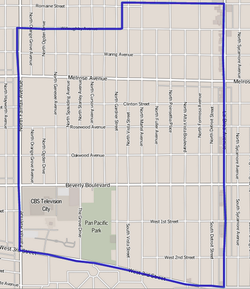
 Map of the Fairfax District of Los Angeles, as delineated by the Los Angeles Times |
|
| Location within Western Los Angeles | |
| Coordinates: 34°04′44″N 118°21′41″W / 34.07884°N 118.361487°W |
The Fairfax District is a 1.23-square-mile neighborhood in the Central Los Angeles region of the city of Los Angeles, California.
Historically the Fairfax District has been a center of the Jewish community in Los Angeles. It is known for the Farmer's Market, The Grove, CBS Television City broadcasting center, the Los Angeles Museum of the Holocaust in Pan Pacific Park, and Fairfax Avenue restaurants and shops.
According to the Mapping L.A. project of the Los Angeles Times, the Fairfax District is flanked on the north and northeast by the city of West Hollywood, on the northeast by Hollywood, on the east by Hancock Park, on the south by Mid-Wilshire, and on the west by Beverly Grove.
Street boundaries are: Willoughby Avenue or Romaine Street on the north, La Brea Avenue on the east, West Third Street on the south, and Fairfax Avenue on the west.
The 2000 U.S. census counted 12,490 residents in the 1.23-square-mile Fairfax District—an average of 10,122 people per square mile, about the same population density as all of Los Angeles. In 2008, the city estimated that the population had increased to 13,360.
...
Wikipedia

