Fairburn, Georgia
|
Fairburn, Georgia Firburnite |
|
|---|---|
| City | |

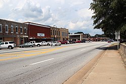
Downtown Fairburn
|
|
 Location in Fulton County and the state of Georgia |
|
| Location in Fulton County and the state of Georgia | |
| Coordinates: 33°33′45″N 84°34′53″W / 33.56250°N 84.58139°WCoordinates: 33°33′45″N 84°34′53″W / 33.56250°N 84.58139°W | |
| Country | United States |
| State | Georgia |
| County | Fulton |
| Government | |
| • Type | Mayor–council government |
| • Mayor | Mario Avery |
| • City Administrator | Tom Barber |
| Area | |
| • Total | 17.1 sq mi (44.2 km2) |
| • Land | 16.9 sq mi (43.6 km2) |
| • Water | 0.2 sq mi (0.5 km2) |
| Elevation | 1,027 ft (313 m) |
| Population (2010) | |
| • Total | 12,950 |
| • Density | 760/sq mi (290/km2) |
| Time zone | Eastern (EST) (UTC-5) |
| • Summer (DST) | EDT (UTC-4) |
| ZIP code | 30213 |
| Area code(s) | 770 |
| FIPS code | 13-28380 |
| GNIS feature ID | 0314030 |
| Website | Fairburn, GA |
Fairburn is a city in Fulton County, Georgia. The population was 12,950 at the 2010 census.
Fairburn is located along a railroad line and was the county seat of Campbell County starting in 1871. It was chosen as county seat in a referendum in 1871 that was spurned on by the original seat of Campbellton refusing to allow the Atlanta & West Point Railroad line through on account of the anticipated noise in the 1850s. The railroad instead passed through Fairburn. Campbellton then faded away as Fairburn grew. The government of Campbell County went bankrupt in 1931 during the Great Depression and, along with Milton County to the north, was absorbed into Fulton County when 1932 began.
Fairburn is located at 33°33′45″N 84°34′53″W / 33.56250°N 84.58139°W (33.562411, -84.581443). Fairburn is located along Interstate 85, which leads northeast 20 miles (32 km) to downtown Atlanta and southwest 142 miles (229 km) to Montgomery, Alabama. Georgia State Route 74 also runs through the city, leading south 13 miles (21 km) to Peachtree City.
...
Wikipedia

