Ewhurst, Surrey
| Ewhurst | |
|---|---|
 Hurt Wood or Ewhurst windmill |
|
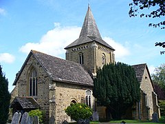
 Church of St Peter and St Paul, Ewhurst |
|
| Ewhurst shown within Surrey | |
| Area | 23.79 km2 (9.19 sq mi) |
| Population | 2,391 (Civil Parish 2011) |
| • Density | 101/km2 (260/sq mi) |
| OS grid reference | TQ090406 |
| • London | 28 mi (45 km) SW |
| Civil parish |
|
| District | |
| Shire county | |
| Region | |
| Country | England |
| Sovereign state | United Kingdom |
| Post town | Cranleigh |
| Postcode district | GU6 |
| Dialling code | 01483 |
| Police | Surrey |
| Fire | Surrey |
| Ambulance | South East Coast |
| EU Parliament | South East England |
| UK Parliament | |
Ewhurst /ˈjuːhɜːrst/ is a rural village and civil parish in the borough of Waverley in Surrey, England. It is located 8.3 miles (13.4 km) south-east of Guildford, 2 miles (3.2 km) east of Cranleigh and 4.5 miles (7.2 km) south of Shere.
The parish includes the smaller hamlets of Ellen's Green and Cox Green near the border with West Sussex. At the north is Hurt Wood, a part of the Surrey Hills AONB. The Greensand Ridge also passes through this area. The rest of the parish, apart from Ewhurst village itself, is classified as an Area of Great Landscape Value (AGLV).
Holmbury Hill with its Iron Age settlements in the parishes of Shere, Guildford borough and Abinger, Mole Valley borough Holmbury St Mary for early British settlers would have been a more suitable, accessible settlement than the denser woodland of this area.
A Roman road NNW to SSE just west of the village centre runs from Rowhook over the Sussex border where it met with England's south Stane Street (stone street) between London and Chichester the other end point is not clear however it was traced in the reign of Victoria by James Park Harrison (1816–1901) and the Rapley Roman villa's remains are west of the village: interesting discoveries include a tile-kiln discovered and excavated in 1836 and from the villa itself in the 1960s, fragments of a glass goblet and an unusual vase decorated with a 'Mural Crown'.
...
Wikipedia

