Ewa Beach, Hawaii
|
ʻEwa Beach, Hawaii ʻEwa |
|
|---|---|
| Census-designated place | |

Aerial photo of the ʻEwa Beach area of Oʻahu
|
|
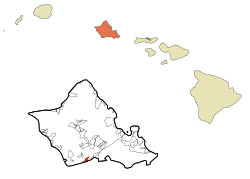
 Location in Honolulu County and the state of Hawaiʻi |
|
| Coordinates: 21°18′56″N 158°0′26″W / 21.31556°N 158.00722°WCoordinates: 21°18′56″N 158°0′26″W / 21.31556°N 158.00722°W | |
| Country | United States |
| State | Hawaiʻi |
| Area | |
| • Total | 1.9 sq mi (4.8 km2) |
| • Land | 1.4 sq mi (3.6 km2) |
| • Water | 0.5 sq mi (1.2 km2) |
| Elevation | 10 ft (3 m) |
| Population (2010) | |
| • Total | 14,955 |
| • Density | 10,682.1/sq mi (4,172.7/km2) |
| Time zone | Hawaii-Aleutian (UTC-10) |
| ZIP code | 96706 |
| Area code(s) | 808 |
| FIPS code | 15-07450 |
| GNIS feature ID | 0358767 |
ʻEwa Beach (/ɛvə/) or simply ʻEwa is a census-designated place (CDP) located in ʻEwa District and the City & County of Honolulu along the leeward coast of Oʻahu in Hawaiʻi. As of the 2010 Census, the CDP had a total population of 14,955. The U.S. postal code for ʻEwa Beach is 96706.
The word ʻewa means "crooked" or "ill-fitting" in Hawaiian. The name comes from the myth that the gods Kāne and Kanaloa threw a stone to determine the boundaries, but it was lost and later found at Pili o Kahe.
Before Ewa Beach became a town it was first a huge plantation farm when Hawaiʻi was under the rule of Queen Liliʻuokalani. After the queen had lost her throne to the Americans, W.R Lowrie became the first plantation manager. Ewa Beach is significant for its association with Ewa Sugar Plantation. Throughout the twentieth century, it played a very influential role in Hawaii's culture, economy, and politics.
Along much of the South Shore of Oʻahu, ʻEwa is a reference to the direction of ʻEwa Beach, roughly westwards along the shore. Related terms are "mauka" (towards the mountains, roughly northwards), "makai" (towards the ocean, roughly South), and Diamond Head or Koko Head, roughly eastwards along the shore.
ʻEwa Beach is located at 21°18'56" North, 158°0'26" West. The main thoroughfare is Fort Weaver Road (State Rte. 76) which runs north (away from the coast) past ʻEwa to Waipahu, connecting there to Farrington Highway (State Rte. 90) and the H-1 freeway.
...
Wikipedia
