Eureka, Illinois
| Eureka | |
| City | |
| Country | United States |
|---|---|
| State | Illinois |
| County | Woodford |
| Elevation | 768 ft (234 m) |
| Coordinates | 40°42′56″N 89°16′31″W / 40.71556°N 89.27528°WCoordinates: 40°42′56″N 89°16′31″W / 40.71556°N 89.27528°W |
| Area | 3.07 sq mi (8 km2) |
| - land | 3.02 sq mi (8 km2) |
| - water | 0.05 sq mi (0 km2) |
| Population | 5,295 (2010) |
| Density | 1,810.5/sq mi (699/km2) |
| Timezone | CST (UTC-6) |
| - summer (DST) | CDT (UTC-5) |
| Postal code | 61530 |
| Area code | 309 |
| FIPS code | 17-24543 |
| GNIS ID | 2394706 |
Eureka is a city in Olio Township, Woodford County, Illinois, United States. The population was 5,295 at the 2010 census. It is the county seat of Woodford County. Eureka is part of the Peoria, Illinois Metropolitan Statistical Area.
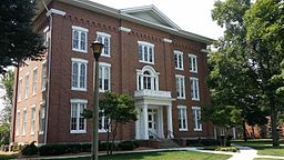
Eureka is a small community centered on the intersection of what is now U.S. 24 and Illinois 117. It is also one of the towns along the Ronald Reagan Trail, a series of roads that connect towns in central Illinois that were of importance to Reagan's early life. President Reagan attended and graduated from Eureka College, whose campus is in Eureka.
Eureka was originally laid out as Walnut Grove in 1855. The name was changed to Eureka because of a naming conflict with another Walnut Grove. Sources differ on who proposed the name Eureka. The city is named from the Greek expression Eureka, meaning "I have found it".
Eureka is located at 40°42′56″N 89°16′31″W / 40.71556°N 89.27528°W (40.715620, -89.275220).
According to the 2010 census, Eureka has a total area of 3.068 square miles (7.95 km2), of which 3.02 square miles (7.82 km2) (or 98.44%) is land and 0.048 square miles (0.12 km2) (or 1.56%) is water.
...
Wikipedia


