Euboia
| Native name: Εύβοια | |
|---|---|

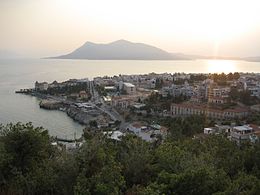
View of Aidipsos
|
|
| Geography | |
| Coordinates | 38°30′N 24°00′E / 38.500°N 24.000°E |
| Archipelago | Aegean Islands |
| Area | 3,684 km2 (1,422 sq mi) |
| Highest elevation | 1,743 m (5,719 ft) |
| Highest point | Dirfi |
| Administration | |
| Region | Central Greece |
| Regional unit | Euboea |
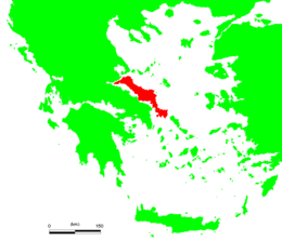
| Municipality | Εύβοια Euboea or Evia (/juːˈbiːə/; Modern Greek: Εύβοια, Evvoia; Ancient Greek: Εὔβοια, Eúboia) is the second-largest Greek island in area and population, after Crete. The narrow Euripus Strait separates it from Boeotia in mainland Greece. In general outline it is a long and narrow, seahorse-shaped island; it is about 180 kilometres (110 mi) long, and varies in breadth from 50 kilometres (31 mi) to 6 kilometres (3.7 mi). Its geographic orientation is from northwest to southeast, and it is traversed throughout its length by a mountain range, which forms part of the chain that bounds Thessaly on the east, and is continued south of Euboea in the lofty islands of Andros, Tinos and Mykonos. It forms most of the regional unit of Euboea, which also includes Skyros and a small area of the Greek mainland. Like most of the Greek islands, Euboea was originally known under other names in Antiquity, such as Macris (Μάκρις) and Doliche (Δολίχη) from its elongated shape, or Ellopia, Aonia and Abantis from the tribes inhabiting it. Its ancient and current name, Εὔβοια, derives from the words εὖ "good", and βοῦς "ox", meaning "the land of the well-fed oxen". In the Middle Ages, the island was often referred to by Byzantine authors by the name of its capital, Chalcis (Χαλκίς) or Euripos (Εὔριπος, the name of the strait that separates the island from the Greek mainland), although the ancient name Euboea remained in use by classicizing authors until the 15th century. ... Wikipedia
...
|

