Etna, PA
| Etna | |
|---|---|
| Borough | |

Carnegie-Illinois steel mill
|
|
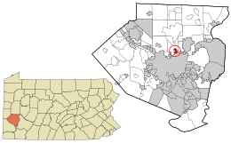
 Location in Allegheny County and the state of Pennsylvania. |
|
 Location of Pennsylvania in the United States |
|
| Coordinates: 40°30′1″N 79°56′56″W / 40.50028°N 79.94889°WCoordinates: 40°30′1″N 79°56′56″W / 40.50028°N 79.94889°W | |
| Country | United States |
| State | Pennsylvania |
| County | Allegheny County |
| Area | |
| • Total | 0.79 sq mi (2.06 km2) |
| • Land | 0.73 sq mi (1.89 km2) |
| • Water | 0.06 sq mi (0.17 km2) |
| Population (2010) | |
| • Total | 3,451 |
| • Estimate (2016) | 3,368 |
| • Density | 4,613.70/sq mi (1,780.40/km2) |
| Time zone | EST (UTC-5) |
| • Summer (DST) | EDT (UTC-4) |
| FIPS code | 42-24160 |
| Website | Borough of Etna |
Etna is a borough in Allegheny County in the U.S. state of Pennsylvania, along the Allegheny River, opposite Pittsburgh. Etna was named after the volcano Mount Etna, an allusion to blast furnaces, steel mills, galvanized-pipe works, and other manufacturers located there. In 1900, 5,384 people lived in Etna. In 1910, 5,830 lived there, and in 1940, 7,223 lived there. The population was 3,451 at the 2010 census.
Etna was the terminus of the No. 2 Pittsburgh Railways streetcar service from downtown Pittsburgh, closed in 1952. From 1907 until 1931, it was a stop on the interurban Pittsburgh and Butler Street Railway, which linked Pittsburgh with Butler.
Etna is located at 40°30′1″N 79°56′56″W / 40.50028°N 79.94889°W (40.500338, -79.948755).
According to the United States Census Bureau, the borough has a total area of 0.8 square miles (2.1 km2), all of it land.
Etna is almost entirely bordered by Shaler Township with its only other border being with the borough of Sharpsburg to the southeast.
...
Wikipedia
