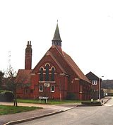
Etchinghill, Kent
| Etchinghill | |
|---|---|
 A converted chapel in Etchinghill |
|
| Etchinghill shown within Kent | |
| District | |
| Shire county | |
| Region | |
| Country | England |
| Sovereign state | United Kingdom |
| Post town | FOLKESTONE |
| Postcode district | CT18 |
| Dialling code | 01303 |
| Police | Kent |
| Fire | Kent |
| Ambulance | South East Coast |
| EU Parliament | South East England |
| UK Parliament | |
Etchinghill is a village in Kent, England, about 5 km north of Hythe, and 1 km north of the Channel Tunnel terminal at Cheriton, near Folkestone. It is in the civil parish of Lyminge. The village has a standard golf course noted for its hills, as well as a pub restaurant called The New Inn which claims to be the closest pub to the Channel Tunnel. Village facilities include a basketball court, two football goals, and a village hall. A large BT Group communication mast, which was used as a telecommunication relay during the Cold War, still stands in the village.
The hamlet of Etchinghill lies at the southern end of the Parish of Lyminge. Its original name was Tettinghelde 1240 (Tetta’s slope). A spring rises to the north side of Westfield Lane, (the road to Tolsford Hill) and the resultant stream flows across the fields to join up with the Nailbourne that rises in Well Field, Lyminge. This stream is known as the East Brook and probably in the Saxon period, when the settlement got its name of Tetinghelde, the volume of water would have been much greater. By the 15th Century the hamlet’s name had altered to “Etynghyld” and “Etynghyll”. Later known as Eachendhill or Etchinghole before settling to become Etchinghill. For centuries the hamlet remained a small farming community around the cross-roads, one of which led to Dover; one going south to Hythe and north to the village of Lyminge where the church is; the track up Westfield Lane over Tolsford Hill led people to West Hythe no doubt, but the importance of this waned as the coastline altered; and a final lane (now vanished) led to Newington.
Over the years the hamlet has grown with additional development on all four of the roads leading from the crossroads, the establishment of a cricket club and, more recently, the creation of a golf course spreading across the land which separates Etchinghill from Lyminge.
To the North-East of the Village are the remains of the Elham Valley Railway, characterised by steep-sided cuttings and tunnels. The line which ran from Canterbury to the port of Folkestone, was closed in 1947 and dismantled between 1950 and 1954. The line is crossed by Teddars Leas Road (bridge) and Badger's Bridge as well as the Golf Course. Although there was no station in Etchinghill, villagers could catch the train by travelling to the neighbouring village of Lyminge, approximately 2 miles to the North via road or one of the many public footpaths.
...
Wikipedia

