Et Tire
Tira
|
||
|---|---|---|
| Hebrew transcription(s) | ||
| • ISO 259 | Ṭira | |
| • Also spelled | Tire (official) | |
 |
||
|
||
| Coordinates: 32°13′56″N 34°56′54″E / 32.23222°N 34.94833°ECoordinates: 32°13′56″N 34°56′54″E / 32.23222°N 34.94833°E | ||
| Grid position | 145/182 PAL | |
| District | Central | |
| Government | ||
| • Type | City | |
| • Mayor | Mamoun Abd al-Hay | |
| Area | ||
| • Total | 11,894 dunams (11.894 km2 or 4.592 sq mi) | |
| Population (2015) | ||
| • Total | 24,873 | |
| Name meaning | The High Land | |
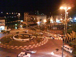
Tira (Arabic: الطـّيرة al-Tira, Hebrew: טִירָה), lit. "The Fort") is a predominantly Arab city in the Central District of Israel. Part of The Triangle, a concentration of Israeli Arab towns and villages adjacent to the Green Line, Tira is close to Kfar Saba, a larger Jewish city, and is well known by its neighbors for its weekly outdoor market, as well as for its Arab cuisine. In 2015 it had a population of 24,873.
In the 12th century, during the Crusader period, the village was owned by the Order of St. John. It was lease to Robert of Sinjil and his heirs. In the 14th and 15th century, Tira was a stop on the road between Gaza and Damascus, and a khan was constructed.
Pierre Jacotin called the village Ertahah on his map from 1799. In 1882, the Palestine Exploration Fund's Survey of Western Palestine described Tira as: "A conspicuous village on a knoll in the plain, surrounded by olives, with a well on the west side."
In the 1922 census of Palestine conducted by the British Mandate authorities, Tireh had a population of 1,588 inhabitants; 1,582 Muslims and 6 Christians, increasing in the 1931 census to 2,192; 2,190 Muslims and 2 Christians, in a total of 380 houses. In 1945, it had 3,180 Arab inhabitants, who owned a total of owned 26,803 dunams of land.
...
Wikipedia


