Ester, Alaska
| Ester, Alaska | |
|---|---|
| Census-designated place | |

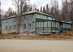
One of the old mining camp buildings
|
|
 Location within Fairbanks North Star Borough and the state of Alaska |
|
| Coordinates: 64°51′21″N 147°58′42″W / 64.85583°N 147.97833°W | |
| Country | United States |
| State | Alaska |
| Borough | Fairbanks North Star |
| Government | |
| • Borough mayor | Karl Kassel |
| • State senators |
Click Bishop (R) John Coghill (R) |
| • State reps. |
David Guttenberg (D) Adam Wool (D) |
| Area | |
| • Total | 64.3 sq mi (166.5 km2) |
| • Land | 64.2 sq mi (166.4 km2) |
| • Water | 0.04 sq mi (0.1 km2) |
| Elevation | 722 ft (220 m) |
| Population (2010) | |
| • Total | 2,422 |
| • Density | 38/sq mi (14.6/km2) |
| Time zone | Alaska (AKST) (UTC-9) |
| • Summer (DST) | AKDT (UTC-8) |
| ZIP code | 99725 |
| Area code(s) | 907 |
| FIPS code | 02-23460 |
| GNIS feature ID | 1397658 |
|
Ester Camp Historic District
|
|
 |
|
| Location | Off AK 3, Ester, Alaska |
|---|---|
| Area | 11.4 acres (4.6 ha) |
| Built | 1906 |
| Architect | Fairbanks Exploration Company |
| NRHP Reference # | 87000703 |
| Added to NRHP | May 6, 1987 |
Ester is a census-designated place (CDP) in Fairbanks North Star Borough, Alaska, United States. It is part of the Fairbanks, Alaska Metropolitan Statistical Area. The population was 2,422 at the 2010 census. The Ester Camp Historic District is a historic district listed on the National Register of Historic Places.
Ester was originally a gold mining camp on Ester Creek, with the first claim staked in February 1903 by Latham A. Jones. Jones worked with the Eagle Mining Company, the biggest claimholder on Glen Gulch in the Rampart mining district, but it was an independent miner, John "Jack" Mihalcik, a Czechoslovakian immigrant born in 1866, who was the first person to actually discover gold on Ester Creek. Mihalcik staked his claim in November 1903 but the news of the discovery of gold did not become public until the following February. By 1907, Ester City had a population of around 200 people, with a thriving mining industry. A social hall was completed in 1907, and was well known throughout the mining district for its dance floor. The hall was used for religious services as well as dances, movies, card games, parties, and other entertainment. The town had five saloons and a couple of hotels. In 1908 and 1910, the hall was the site of campaign speeches by candidates for the seat of Territorial Delegate. (Labor won in 1908, but Judge James Wickersham won the Ester precinct in 1910.) By 1909 Ester City had a baseball field, a doctor, a mine workers' union local, and a teacher, but gold production was beginning to decline.
The Berry Post Office moved in 1910 from near the Berry brothers' claim about two miles downstream from Ester City into J.C. Kinney's general store in Ester. (The post office retained the name of Berry until 1965, when it was finally changed to that of the town it had been in for 55 years.) In the mid-1920s, the Fairbanks Exploration Company began buying claims on Ester Creek, started operations in 1929, and in 1933 built a mess hall for their camp in Ester (now a historic landmark used until 2008 as a tourist attraction and hotel). The F.E. Company revitalized the town, but they also literally reshaped it, doing large-scale open-pit mining using enormous floating dredges and draglines, removing in the process much of the original sites of Berry and Ester.
...
Wikipedia
