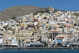
Ermoupoli
|
Ermoupoli Ερμούπολη |
||
|---|---|---|

Ermoupoli port
|
||
|
||
| Coordinates: 37°26′N 24°55′E / 37.433°N 24.917°ECoordinates: 37°26′N 24°55′E / 37.433°N 24.917°E | ||
| Country | Greece | |
| Administrative region | South Aegean | |
| Regional unit | Syros | |
| Municipality | Syros-Ermoupoli | |
| • Municipal unit | 11.2 km2 (4.3 sq mi) | |
| Elevation | 20 m (70 ft) | |
| Population (2011) | ||
| • Municipal unit | 13,737 | |
| • Municipal unit density | 1,200/km2 (3,200/sq mi) | |
| Community | ||
| • Population | 11,407 (2011) | |
| Time zone | EET (UTC+2) | |
| • Summer (DST) | EEST (UTC+3) | |
| Postal code | 841 00 | |
| Area code(s) | 22810 | |
| Vehicle registration | ΕΜ | |
| Website | www.hermoupolis.gr | |
Ermoupoli (Greek: Ερμούπολη), also known by the formal older name Ermoupolis or Hermoupolis (Greek: Ἑρμούπολις < Ἑρμοῦ πόλις "Town of Hermes"), is a town and former municipality on the island of Syros, in the Cyclades, Greece. Since the 2011 local government reform, it is part of the municipality Syros-Ermoupoli, of which it is the seat and a municipal unit. It is also the capital of the South Aegean region. The municipal unit has an area of 11.181 km2.
Ermoupoli was founded during the Greek Revolution in the 1820s, as an extension to the existing Ano Syros township. It soon became the leading commercial and industrial center of Greece, as well as its main port. The renowned Greek Steamship Company was founded in the city in 1856. Thousands of ships were built in the various Syros shipyards.
Eventually Ermoupoli was eclipsed by Piraeus in the late 19th century. In the following decades the city declined. Recently, its economy has greatly improved, based on the service industry.
The City Hall, Miaoulis Square
Postcard of Ermoupoli, 1904
Vaporia
Ermoupoli at night
...
Wikipedia


