Erbeskopf
| Erbeskopf | |
|---|---|

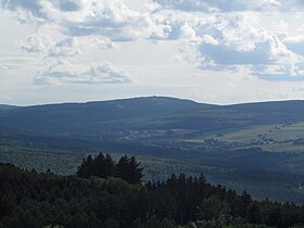
Erbeskopf from the northeast (Wildenburg Castle)
|
|
| Highest point | |
| Elevation | 816.32 m above sea level (NHN) (2,678.2 ft) |
| Prominence | 571 m ↓ Bruchhof, Homburg |
| Isolation | 113 km → Großer Feldberg |
| Coordinates | 49°43′50″N 7°05′26″E / 49.730444°N 7.090639°ECoordinates: 49°43′50″N 7°05′26″E / 49.730444°N 7.090639°E |
| Geography | |
| Parent range | Hunsrück |
The Erbeskopf is a mountain in the Hunsrück range in central Germany. At a height of 816 metres (2,677 ft), it is the highest point in the state of Rhineland-Palatinate, as well as the highest point of German territory on the western bank of the Rhine. It lies within the Saar-Hunsrück Nature Park.
The Erbeskopf lies in the southwest of the Hunsrück and the Idar Forest - forming part of both natural regions - near their boundary with the Schwarzwalder Hochwald, to which it belongs morphologically. Its largest part and the summit are part of the municipality of Hilscheid in the county of Bernkastel-Wittlich. The rest belongs to Allenbach in the county of Birkenfeld. Its northeasterly neighbour, also in the Idar Forest, is the Kahlheid (766 m).
The streams that rise near on the Erbeskopf are: the Idarbach whose source lies to the northeast below the subpeak of Sandkopf and thus south of the Kahlheid; the Thranenbach, the upper course of the Traunbach, whose source is southeast of the summit; the Hohltriefbach, whose source lies below the subpeak of Springenkopf and is a tributary of the Röderbach which rises northwest of the Erbeskopf; and the Simm to the north, a tributary of the Schalesbach.
In 2008 a re-survey of the height of the Erbeskopf was conducted by the Rhineland-Palatinate State Office of Survey and Geobasis Information (Landesamt für Vermessung und Geobasisinformation Rheinland-Pfalz); using two independent survey measurements that each gave a height of 816.32 m.
Its subpeaks, with their heights in metres (m) above sea level (Normalhöhennull or NHN), are:
...
Wikipedia

