Enkirch
| Enkirch | ||
|---|---|---|
 |
||
|
||
| Coordinates: 49°58′59″N 07°07′36″E / 49.98306°N 7.12667°ECoordinates: 49°58′59″N 07°07′36″E / 49.98306°N 7.12667°E | ||
| Country | Germany | |
| State | Rhineland-Palatinate | |
| District | Bernkastel-Wittlich | |
| Municipal assoc. | Traben-Trarbach | |
| Government | ||
| • Mayor | Karl-Heinz Weisgerber (SPD) | |
| Area | ||
| • Total | 25.43 km2 (9.82 sq mi) | |
| Elevation | 105 m (344 ft) | |
| Population (2015-12-31) | ||
| • Total | 1,462 | |
| • Density | 57/km2 (150/sq mi) | |
| Time zone | CET/CEST (UTC+1/+2) | |
| Postal codes | 56850 | |
| Dialling codes | 06541 | |
| Vehicle registration | WIL | |
| Website | www.enkirch.de | |
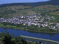
Enkirch is an Ortsgemeinde – a municipality belonging to a Verbandsgemeinde, a kind of collective municipality – in the Bernkastel-Wittlich district in Rhineland-Palatinate, Germany.
The municipality lies below Traben-Trarbach at the mouth of a branched brook, the Ahringsbach, coming from the Hunsrück on the Moselle’s right bank, and some 52 km south of Cochem. From Enkirch to its mouth on the Rhine at the Deutsches Eck in Koblenz, the Moselle covers a distance of 102 km. Near Enkirch is a weir on the Moselle.
Enkirch belongs to the Verbandsgemeinde of Traben-Trarbach, whose seat is in the like-named town.
It is assumed that there has been continuous habitation at what is now Enkirch for some 2,500 years, but the first traces of this go all the way back to the Stone Age.
Enkirch was already an important centre as early as Celtic times, and then on into Roman times. On 1 April 733, Enkirch had its first documentary mention in the noblewoman Adela’s will as Anchiriacum. It was mentioned for the second time on 10 February 908 by King Ludwig IV when he donated the church and manse to Archbishop Radbod of Trier. The document in question refers to the village as Ancaracha. The municipality’s name evolved through the forms Enkricha, Einkirke and Enkerich before settling on today’s form, Enkirch.
...
Wikipedia


