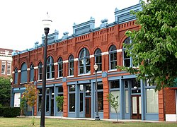
Emory Place Historic District
|
Emory Place Historic District
|
|

6-12 Emory Place
|
|
| Location | Roughly bounded by Broadway, N. Central, Emory, Fifth, East Fourth, and King Knoxville, Tennessee |
|---|---|
| Coordinates | 35°58′26.65″N 83°55′20.94″W / 35.9740694°N 83.9224833°WCoordinates: 35°58′26.65″N 83°55′20.94″W / 35.9740694°N 83.9224833°W |
| Area | approximately 10 acres (4.0 ha) |
| Built | 1880–1930 |
| Architect | Charles I. Barber, Albert Baumann, Sr., Dean Parmalee, R. F. Graf, etc. |
| Architectural style | Romanesque Revival, Neoclassical Revival |
| NRHP reference # | 94001259 |
| Added to NRHP | November 10, 1994 |
The Emory Place Historic District is a historic district in Knoxville, Tennessee, United States, located just north of the city's downtown area. The district consists of several commercial, residential, religious, and public buildings that developed around a late nineteenth century train and trolley station. The district includes the Knoxville High School building, St. John's Lutheran Church, First Christian Church, and some of the few surviving rowhouses in Knoxville. The district was listed on the National Register of Historic Places in 1994.
Following railroad construction in the 1850s, Knoxville slowly expanded northward. In 1890, the "Dummy Line," a railroad line connecting Knoxville and Fountain City, was established, with what is now Emory Place as its southern terminus. A farmers' market and several small industrial and commercial firms developed adjacent to the train station to take advantage of the influx of customers and transportation advantages. While Emory Place declined with the dismantling of Knoxville's trolley system in the late 1940s, many of its late-nineteenth and early-twentieth century buildings still stand, and have been restored.
The Emory Place Historic District is situated around a triangular-shaped area created by the intersections of Broadway and Central Street on the north, Broadway and Fifth Avenue on the southwest, and Central and Fifth on the southeast.Interstate 40 and the Southern Railway tracks divide the district from downtown Knoxville to the south. The Fourth and Gill neighborhood lies to the north, and Old Gray Cemetery lies opposite Broadway to the west.
Emory Place itself is a cross street connecting Central and Broadway. The street was once a wide avenue, much of which has been converted into parking space. Gay Street, downtown Knoxville's main thoroughfare, traverses the Emory Place Historic District, and terminates at Emory Place.
...
Wikipedia


