Emerald Mound Site
|
Emerald Mound Site
|
|

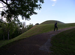
The western end of Emerald Mound, showing the larger of the two secondary mounds.
|
|
| Nearest city | Stanton, Mississippi |
|---|---|
| Coordinates | 31°38′9.98″N 91°14′50.02″W / 31.6361056°N 91.2472278°WCoordinates: 31°38′9.98″N 91°14′50.02″W / 31.6361056°N 91.2472278°W |
| NRHP Reference # | 88002618 |
| Significant dates | |
| Added to NRHP | November 18, 1988 |
| Designated NHL | December 29, 1989 |
The Emerald Mound Site (22 AD 504), also known as the Selsertown site, is a Plaquemine culture Mississippian period archaeological site located on the Natchez Trace Parkway near Stanton, Mississippi, United States. The site dates from the period between 1200 and 1730 CE. It is the type site for the Emerald Phase (1500 to 1680 CE) of the Natchez Bluffs Plaquemine culture chronology and was still in use by the later historic Natchez people for their main ceremonial center. The platform mound is the second-largest Pre-Columbian earthwork in the country, after Monk's Mound at Cahokia, Illinois.
The mound covers eight acres, measuring 770 feet (230 m) by 435 feet (133 m) at the base and is 35 feet (11 m) in height. Emerald Mound has a flat top with two smaller secondary mounds at each end. It was constructed around a natural hill. Travelers in the early 19th century noted a number of adjoining mounds and an encircling ditch that are no longer present.This site once had six other secondary mounds which were lost due to the plowing of the surface of the mound. Emerald Mound was stabilized by the National Park Service in 1955. It was declared a National Historic Landmark in 1989.
Emerald Mound was constructed during 1250 and 1600 CE, and is the type site for the Emerald Phase (1500 - 1680) of the Plaquemine culture Natchez Bluffs chronology. It was used as a ceremonial center for a population who resided in outlying villages and hamlets, but takes its name from the historic Emerald Plantation that surrounded the mound in the 19th century. The large mound began as a natural hill, which was built up by workers' depositing earth along the sides, reshaping it and creating an elongated, pentagonal-shaped, artificial plateau. Two smaller mounds sit on either end of the summit of the primary mound. The larger of the two sits at the western end, and measures 190 feet (58 m) by 160 feet (49 m) at the base and is 30 feet (9.1 m) in height. The smaller mounds on the summit are believed to be platforms for homes of chiefs and other key leaders.
...
Wikipedia


