Embarras River (Illinois)
| Embarras River | |
|---|---|

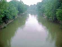
The Embarras River at Lawrenceville
|
|
| Basin features | |
| Main source |
Champaign, Illinois 40°05′22″N 88°15′30″W / 40.0894756°N 88.2583836°W |
| River mouth |
Confluence with the Wabash River southeast of Lawrenceville, Illinois 397 ft (121 m) 38°38′35″N 87°37′02″W / 38.6431028°N 87.6172464°WCoordinates: 38°38′35″N 87°37′02″W / 38.6431028°N 87.6172464°W |
| Progression | Embarras River → Wabash → Ohio → Mississippi → Gulf of Mexico |
| Physical characteristics | |
| Length | 195 mi (314 km) |
| GNIS ID | 407983 |
The Embarras River (/ˈɛmbrɑː/ EM-brah) is a 195-mile-long (314 km)tributary of the Wabash River in southeastern Illinois in the United States. The waters of the Embarras reach the Gulf of Mexico via the Wabash, Ohio, and Mississippi Rivers. The river drains a watershed around 1,566,450 acres (6,339.2 km2) in an agricultural region. The name comes from French explorers, who used the term embarras for river obstacles, blockages, and difficulties relating to logjams and the like.
The Embarras River rises in Champaign County. The upper reaches of the Embarras include the detention ponds near the intersection of Windsor Road with U.S. Route 45 in southeastern Champaign; the southern portion of the University of Illinois campus, including the small creek near the Vet Med Building; and Meadowbrook Park in south Urbana.
The Embarras flows generally southward through Douglas, Coles, Cumberland, and Jasper Counties. In Jasper County, it turns southeast for the remainder of its course through Richland, Crawford, and Lawrence Counties. Portions of the river's lower course have been straightened and channelized. It joins the Wabash River 6 miles (10 km) southwest of Vincennes, Indiana.
...
Wikipedia
