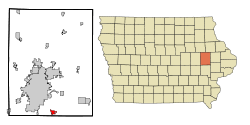
Ely, Iowa
| Ely, Iowa | |
|---|---|
| City | |
 |
|
 Location of Ely, Iowa |
|
| Coordinates: 41°52′32″N 91°34′59″W / 41.87556°N 91.58306°WCoordinates: 41°52′32″N 91°34′59″W / 41.87556°N 91.58306°W | |
| Country |
|
| State |
|
| County | Linn |
| Area | |
| • Total | 1.44 sq mi (3.73 km2) |
| • Land | 1.44 sq mi (3.73 km2) |
| • Water | 0 sq mi (0 km2) |
| Elevation | 738 ft (225 m) |
| Population (2010) | |
| • Total | 1,776 |
| • Estimate (2012) | 1,880 |
| • Density | 1,233.3/sq mi (476.2/km2) |
| Time zone | Central (CST) (UTC-6) |
| • Summer (DST) | CDT (UTC-5) |
| ZIP code | 52227 |
| Area code(s) | 319 |
| FIPS code | 19-25365 |
| GNIS feature ID | 0456356 |
Ely is a city in Linn County, Iowa, United States. The population was 1,776 at the 2010 census. It is part of the Cedar Rapids Metropolitan Statistical Area.
Ely was laid out in 1872 as an outgrowth on the Burlington, Cedar Rapids and Northern Railway.
The following properties in Ely are listed on the National Register of Historic Places:
Ely is located at 41°52′32″N 91°34′59″W / 41.87556°N 91.58306°W (41.875431, -91.583061).
According to the United States Census Bureau, the city has a total area of 1.44 square miles (3.73 km2), all of it land.
As of the census of 2010, there were 1,776 people, 628 households, and 466 families residing in the city. The population density was 1,233.3 inhabitants per square mile (476.2/km2). There were 650 housing units at an average density of 451.4 per square mile (174.3/km2). The racial makeup of the city was 97.5% White, 0.3% African American, 0.1% Native American, 0.5% Asian, 0.6% from other races, and 1.0% from two or more races. Hispanic or Latino of any race were 2.3% of the population.
...
Wikipedia
