Elwood, Nebraska
| Elwood, Nebraska | |
|---|---|
| Village | |

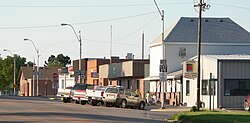
Downtown Elwood: Smith Avenue
|
|
 Location of Elwood, Nebraska |
|
| Coordinates: 40°35′19″N 99°51′38″W / 40.58861°N 99.86056°WCoordinates: 40°35′19″N 99°51′38″W / 40.58861°N 99.86056°W | |
| Country | United States |
| State | Nebraska |
| County | Gosper |
| Area | |
| • Total | 0.52 sq mi (1.35 km2) |
| • Land | 0.52 sq mi (1.35 km2) |
| • Water | 0 sq mi (0 km2) |
| Elevation | 2,667 ft (813 m) |
| Population (2010) | |
| • Total | 707 |
| • Estimate (2012) | 699 |
| • Density | 1,359.6/sq mi (524.9/km2) |
| Time zone | Central (CST) (UTC-6) |
| • Summer (DST) | CDT (UTC-5) |
| ZIP code | 68937 |
| Area code(s) | 308 |
| FIPS code | 31-15570 |
| GNIS feature ID | 0829101 |
Elwood is a village in Gosper County, Nebraska, United States. It is part of the Lexington, Nebraska Micropolitan Statistical Area. The population was 707 at the 2010 census. It is the county seat of Gosper County.
Elwood was platted in 1885 when the Chicago, Burlington and Quincy Railroad was extended to that point. It was named for Elwood Thomas, a homesteader.
The Gosper County Courthouse in Elwood is on the National Register of Historic Places. The Art Deco building was designed by the Kearney architectural firm of McClure & Walker.
Elwood is located at 40°35′19″N 99°51′38″W / 40.58861°N 99.86056°W (40.588632, -99.860603).
According to the United States Census Bureau, the village has a total area of 0.52 square miles (1.35 km2), all of it land.
Elwood is located at the junction of Nebraska Highway 23 and U.S. Highway 283, and is south of Elwood Reservoir. In Elwood, the two highways respectively follow Ripley Street and Smith Street.
...
Wikipedia
