Elmbridge Borough Council
| Borough of Elmbridge | |
|---|---|
| Non-metropolitan district | |
 |
|
| Motto(s): Dum Defluant Amnes (Latin: Until the rivers cease to flow) |
|
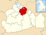
 Elmbridge shown within Surrey |
|
| Sovereign state | United Kingdom |
| Constituent country | England |
| Region | South East England |
| Non-metropolitan county | Surrey |
| Status | Non-metropolitan district |
| Admin HQ | Esher |
| Incorporated | 1 April 1974 |
| Government | |
| • Type | Non-metropolitan district council |
| • Body | Elmbridge Borough Council |
| • Leadership | Leader & Cabinet (RA / Liberal Democrat / Independent) |
| • MPs |
Philip Hammond Dominic Raab |
| Area | |
| • Total | 37.2 sq mi (96.3 km2) |
| Area rank | 226th (of 326) |
| Population (mid-2016 est.) | |
| • Total | 132,800 |
| • Rank | 162nd (of 326) |
| • Density | 3,600/sq mi (1,400/km2) |
| • Ethnicity | 94.0% White 2.3% S.Asian |
| Time zone | GMT (UTC0) |
| • Summer (DST) | BST (UTC+1) |
| ONS code | 43UB (ONS) E07000207 (GSS) |
| OS grid reference | TQ1402064766 |
| Website | www |
Elmbridge is a local government district with borough status in Surrey, England. Its principal towns are Esher, Walton-on-Thames and Weybridge.
The borough shares a long boundary with Greater London—the London Borough of Richmond upon Thames to the north, with which the border is formed by the Thames itself, and the Royal Borough of Kingston upon Thames to the east. Running anticlockwise from the northwest, Elmbridge borders the Surrey boroughs of Spelthorne, Runnymede, Woking, Guildford and Mole Valley. Elmbridge is almost entirely within the bounds of the M25 motorway. There is only one civil parish, Claygate, while the remainder of the area has two rather than three tiers of local government. Responsibility for some designated services is with Surrey County Council, such as social services and transport.
In common with the nearby Surrey boroughs of Spelthorne and Epsom and Ewell, much of Elmbridge is a continuation of the built-up area of suburban London, and the areas of Molesey, Long Ditton, Thames Ditton, Hinchley Wood, Esher and Claygate lie within the social and commercial orbit of neighbouring Kingston upon Thames (East Elmbridge, for example, is served by Kingston Hospital, while Molesey, the Dittons and Claygate fell under the jurisdiction of the Metropolitan Police for more than one-hundred and sixty years). During the period of review towards a 1992 report by the Local Government Boundary Commission for England (Report No 627, 'The Boundaries of Greater London and the London Boroughs'), the Commission received a submission 'from a small London borough (Kingston upon Thames), making a case for increased size'. The final report noted Kingston's claim 'that it could define its "objective community"', while a further report of the same year (Report No 666, 'Review of Greater London, the London Boroughs and the City of London') noted Kingston's recommendation to encompass 'within its authority a wider area of Elmbridge, including Long and Thames Ditton, Hinchley Wood, Weston Green and the Moleseys'. In the light of this, and in the light of Report 627's conclusion that 'there were considerable anomalies in the boundaries, especially the outer London boundary in South West London around Kingston', the report considered 'that there was a strong case to align the boundary [of Greater London] with the edge of the built-up area, thus bringing into London boroughs parts of Surrey'. The report thus recommended 'a wider review of these boundaries in the future'.
...
Wikipedia
