Long Ditton
| Long Ditton | |
|---|---|
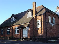
 The Village Hall |
|
| Long Ditton shown within Surrey | |
| Area | 2.14 km2 (0.83 sq mi) |
| Population | 6,343 (2011 census) |
| • Density | 2,964/km2 (7,680/sq mi) |
| OS grid reference | TQ169664 |
| Civil parish |
|
| District | |
| Shire county | |
| Region | |
| Country | England |
| Sovereign state | United Kingdom |
| Post town | Surbiton Thames Ditton |
| Postcode district | KT6 KT7 |
| Dialling code | 020 |
| Police | Surrey |
| Fire | Surrey |
| Ambulance | South East Coast |
| EU Parliament | South East England |
| UK Parliament | |
Long Ditton is a residential suburb in Surrey, England on the boundary with the Royal Borough of Kingston upon Thames, London. In medieval times it was a village, occupying a narrow strip of land. Neighbouring settlements include Hinchley Wood, Thames Ditton and Surbiton.
Its northernmost part is 1.5 miles (2.4 km) south-west of central Kingston upon Thames, 11.3 miles from Charing Cross, and 15 miles (24 km) north-east of Guildford, the county town. It is briefly cut in its middle by the South Western Main Line and is bordered by a straight east-west spur road to meet the A3 in a cutting to the south. The old Portsmouth Road passes by the River Thames in the northern end of the village and the south bank here is privately owned.
In both local economy and public transport the high street and railway stations at Hinchley Wood and Surbiton are the nearest such amenities. Surbiton has many restaurants and cafés.
Ditton was a Saxon settlement which, by Domesday, was a single ecclesiastical parish but split in two, as it remains. This split was between the riverside manor and parish of Thames Ditton, and the longer, eastern area, Long Ditton, which is a long rectangle of land extending from developed land by the River Thames to Ditton Hill. Nowadays Ditton Hill reaches beyond the wide A3 and A309 as far as Woodstock Lane South, much of which is in Claygate parish (and has an Esher postal address).
...
Wikipedia

