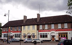
Elm Park
| Elm Park | |
|---|---|
 Elm Park Hotel opened in 1938 as the only pub |
|
| Elm Park shown within Greater London | |
| Population | 12,466 (2011 Census. Ward) |
| OS grid reference | TQ525855 |
| • Charing Cross | 14.3 mi (23.0 km) WSW |
| London borough | |
| Ceremonial county | Greater London |
| Region | |
| Country | England |
| Sovereign state | United Kingdom |
| Post town | HORNCHURCH |
| Postcode district | RM12 |
| Dialling code | 01708 |
| Police | Metropolitan |
| Fire | London |
| Ambulance | London |
| EU Parliament | London |
| UK Parliament | |
| London Assembly | |
Elm Park is a suburban district in east London, England, and part of the London Borough of Havering. Located 14.3 miles (23.0 km) east-northeast of Charing Cross, it is identified as a district centre in the London Plan with several streets of shops and a priority for regeneration. Prior to the construction of the extensive Elm Park Garden City development in the 1930s it was a scattered settlement of farms in the south of the parish of Hornchurch. Elm Park has been connected to central London by the electrified District line service since 1935 and the planned development of the area formed part of the interwar private housing boom that was interrupted by World War II. After the war Elm Park expanded with social housing and it has formed part of Greater London since 1965.
The place name Elm Park was devised in 1933. It was derived from Elm Farm, which is first recorded in 1777 and was known as Elms in 1883.
The area that became Elm Park formed part of the South End ward of the parish of Hornchurch; the large ancient parish occupied the same area as the royal manor and liberty of Havering. The Havering courts and Hornchurch vestry were the principal local government in the area. The liberty was abolished in 1892 and the parish vestry in 1894. Elected local government was incorporated by the Local Government Act 1894. Hornchurch civil parish was governed by Hornchurch Parish Council and formed part of the Romford Rural District, governed by Romford Rural District Council.
In 1926 the Hornchurch parish was removed from the rural district to become Hornchurch Urban District and the parish council became Hornchurch Urban District Council. The council, based in Langtons House from 1929, was the planning authority during the transition of Elm Park from farms to suburban development. The Hornchurch Urban District was abolished in 1965 and Elm Park became part of the London Borough of Havering in Greater London.
...
Wikipedia

