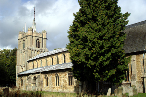
Elm, Cambridgeshire
| Elm | |
|---|---|
 All Saints Church, Elm |
|
| Elm shown within Cambridgeshire | |
| Population | 3,962 (2011) |
| OS grid reference | TF477062 |
| District | |
| Shire county | |
| Region | |
| Country | England |
| Sovereign state | United Kingdom |
| Post town | Wisbech |
| Postcode district | PE14 |
| Dialling code | 01945 |
| Police | Cambridgeshire |
| Fire | Cambridgeshire |
| Ambulance | East of England |
| EU Parliament | East of England |
| UK Parliament | |
Elm is a Fenland village in Cambridgeshire, England. The civil parish of Elm had a resident population of 3,295, as recorded during the 2001 United Kingdom census. The population including Coldham, Collett's Bridge, Friday Bridge and Ring's End was 3,962 at the 2011 Census. It is located alongside the county boundary with Norfolk, on the outskirts of the market town of Wisbech. The northern end of Elm, alongside Elm Low Road, acts as an adjacent suburb of Wisbech. Elm is situated in the heart of The Fens.
Situated in the Fens, much of the parish would have been undrained salt marsh and salt lagoon, with any higher areas, such as that around Wisbech, forming fen-islands. Mesolithic hunter-gatherers would have fished and hunted waterfowl from these islands. Later, farmers would have grazed their sheep and other livestock on the rich marsh pastures. The area was also occupied during the Roman period, with domestic finds scattered through the parish, concentrating along the Leam stream that may have been canalised during the Roman period. Asides from agriculture, there is archaeological evidence of salt processing in the Elm area.
Drainage and falling sea levels may have prompted the settlement of Elm by the Medieval period. In the 13th Century the parish was prosperous enough to fund the building of a significantly extravagant church. However, the lower laying parts of the parish were probably not fully drained and reclaimed until as recently as between the 17th and 19th Centuries. Later satellite settlements formed to the south of the parish at Friday Bridge and at Coldham, alongside the Leam, where land was better drained.
Elm, or Elme, once had a stop on the Wisbech and Upwell Tramway, known as Elmbridge as it was located just over the border in Norfolk near to a bridge that spanned the former Wisbech Canal. This canal connected the River Nene at Wisbech, to a junction with the Well Creek and the Old River Nene at Outwell, and passed along the northern edge of Elm.
...
Wikipedia

