Ellsworth, PA
| Ellsworth | |
|---|---|
| Borough | |

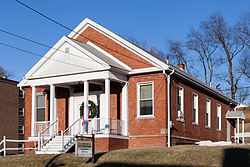
Borough Building in 2015
|
|
 Location of Ellsworth in Washington County, Pennsylvania. |
|
| Location of Ellsworth in Pennsylvania | |
| Coordinates: 40°6′21″N 80°1′14″W / 40.10583°N 80.02056°WCoordinates: 40°6′21″N 80°1′14″W / 40.10583°N 80.02056°W | |
| Country | United States |
| State | Pennsylvania |
| County | Washington |
| Established | 1900 |
| Government | |
| • Mayor | Joseph Daniel Kudlac |
| Area | |
| • Total | 0.76 sq mi (1.96 km2) |
| • Land | 0.74 sq mi (1.91 km2) |
| • Water | 0.02 sq mi (0.04 km2) |
| Population (2010) | |
| • Total | 1,027 |
| • Estimate (2016) | 986 |
| • Density | 1,334.24/sq mi (515.06/km2) |
| Time zone | EST (UTC-4) |
| • Summer (DST) | EDT (UTC-5) |
| Area code(s) | 724 |
Ellsworth is a borough in Washington County, Pennsylvania, United States. The population was 1,083 at the 2000 census. The coal town was founded by James Ellsworth who bought up the land in 1890s, developed the Monongahela Railway, and sold the mines to Bethlehem Steel in the 1920s.
Ellsworth is located at 40°6′21″N 80°1′14″W / 40.10583°N 80.02056°W (40.105887, -80.020455).
According to the United States Census Bureau, the borough has a total area of 0.8 square miles (2.1 km2), of which, 0.7 square miles (1.8 km2) of it is land and 0.04 square miles (0.10 km2) of it (2.63%) is water.
As of the census of 2000, there were 1,083 people, 484 households, and 291 families residing in the borough. The population density was 1,467.7 people per square mile (565.1/km²). There were 528 housing units at an average density of 715.6 per square mile (275.5/km²). The racial makeup of the borough was 96.03% White, 2.31% African American, 0.09% Asian, 0.09% from other races, and 1.48% from two or more races. Hispanic or Latino of any race were 0.65% of the population.
...
Wikipedia

