Ellenville, New York
| Ellenville | |
|---|---|
| Village | |

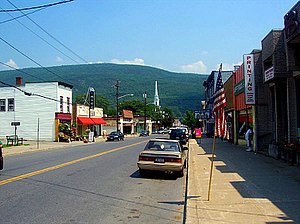
Downtown Ellenville, looking east along Canal Street (NY 52) toward the Shawangunk Ridge
|
|
 Location in Ulster County and the state of New York. |
|
| Location within the state of New York --> | |
| Coordinates: 41°43′01″N 74°23′36″W / 41.71694°N 74.39333°WCoordinates: 41°43′01″N 74°23′36″W / 41.71694°N 74.39333°W | |
| Country | United States |
| State | New York |
| County | Ulster |
| Town | Wawarsing |
| Area | |
| • Total | 8.8 sq mi (22.7 km2) |
| • Land | 8.7 sq mi (22.5 km2) |
| • Water | 0.1 sq mi (0.2 km2) |
| Elevation | 338 ft (103 m) |
| Population (2010) | |
| • Total | 4,135 |
| • Density | 475.3/sq mi (183.8/km2) |
| Time zone | Eastern (EST) (UTC-5) |
| • Summer (DST) | EDT (UTC-4) |
| ZIP code | 12428 |
| Area code(s) | 845 Exchanges: 210, 647. |
| FIPS code | 36-23965 |
| GNIS feature ID | 0949508 |
Ellenville is a village in Ulster County, New York, United States. The population was 4,135 at the 2010 census. The ZIP code is 12428. Telephone service is provided by the 210 and 647 exchanges in Area Code 845.
The village of Ellenville is within the town of Wawarsing, approximately ninety miles northwest of New York City and ninety miles southwest of Albany. The village is located at the junction of Routes NY 52 and US 209 and is bisected by the recently designated Shawangunk Scenic Byway. Ellenville lies in the Rondout Valley, at the eastern base of the Catskill Mountains, and the western base of the Shawangunk Ridge, which is listed by The Nature Conservancy as one of the "75 Last Great Places on Earth."
The north-flowing Sandburg Creek and east-flowing Beer Kill intersect in Ellenville near the current site of the Ellenville Central School to become the Rondout Creek, which flows north to join the Hudson River near Kingston. Ellenville is within the Hudson River Valley National Heritage Area.
According to the United States Census Bureau, the village has a total area of 8.8 square miles (22.7 km²). 8.7 square miles (22.6 km²) of it is land and 0.1 square miles (0.2 km²) of it is water. The total area is 0.68% water.
As of the census of 2010, there were 4,135 people, 1,578 households (occupied housing units), and 1,047 families residing in the village. The population density was 475.3 inhabitants per square mile (183.8/km²). There were 1,845 total housing units at an average density of 212.1 per square mile (82.0/km²). The racial makeup of the village was 68.16% White, 13.7% African American, 1.3% Native American, 2.4% Asian, 0.1% Pacific Islander, 7.7% from other races, and 6.7% from two or more races. 27.9% of the population were Hispanic or Latino of any race.
...
Wikipedia

