Elizabethtown, Illinois
| Elizabethtown | |
| Village | |
|
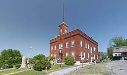
Hardin County Court House in Elizabethtown
|
|
| Country | United States |
|---|---|
| State | Illinois |
| County | Hardin |
| Coordinates | 37°26′57″N 88°18′13″W / 37.44917°N 88.30361°WCoordinates: 37°26′57″N 88°18′13″W / 37.44917°N 88.30361°W |
| Area | 0.71 sq mi (2 km2) |
| - land | 0.70 sq mi (2 km2) |
| - water | 0.00 sq mi (0 km2) |
| Population | 348 (2000) |
| Density | 495.6/sq mi (191/km2) |
| Timezone | CST (UTC-6) |
| - summer (DST) | CDT (UTC-5) |
| Postal code | 62931 |
| Area code | 618 |
| FIPS code | 17-23191 |
| GNIS ID | 2398801 |
Elizabethtown is a village in Hardin County, Illinois, along the Ohio River. The population was 348 at the 2000 census. It is the county seat of Hardin County. It is the location of the Rose Hotel, an Illinois state historic site built about 1830. The village of Elizabethtown was founded around the McFarland Tavern (1812), which was soon rebuilt as the Rose Hotel, the rebuilt hostelry is the oldest hotel in the state of Illinois. Elizabethtown was named after James McFarland's wife. The oldest Baptist church in Illinois is also located in Elizabethtown.
Elizabethtown is located at 37°26′57″N 88°18′13″W / 37.44917°N 88.30361°W (37.449136, -88.303748).
According to the 2010 census, Elizabethtown has a total area of 0.715 square miles (1.85 km2), of which 0.71 square miles (1.84 km2) (or 99.3%) is land and 0.005 square miles (0.01 km2) (or 0.7%) is water.
As of the 2000 United States Census, there were 348 people, 183 households, and 99 families residing in the village. The population density was 495.6 people per square mile (191.9/km²). There were 226 housing units at an average density of 321.9 per square mile (124.7/km²). The racial makeup of the village was 97.99% White, 1.44% African American, and 0.57% from two or more races. Hispanic or Latino of any race were 0.29% of the population.
...
Wikipedia


