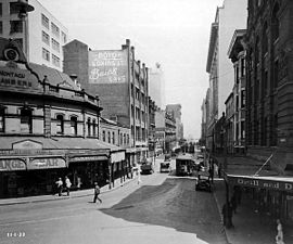
Elizabeth Street, Sydney
|
Elizabeth Street New South Wales |
|
|---|---|
 |
|
| Elizabeth Street, looking south from the intersection of Hunter Street, 11 January 1933. | |
| Hunter Street, Sydney CBD and south to Zetland | |
| Type | Street |
| Length | 8.6 km (5.3 mi) |
| Gazetted | 1810 |
| North end | Hunter Street, Sydney CBD |
| Market, Park, Liverpool. Goulburn Streets, Sydney; Wentworth Avenue, Albion Street and Eddy Avenue, Surry Hills; Cleveland, Redfern, Phillip Streets, Redfern; McEvoy and Bourke Streets, Waterloo. | |
| South south-east end | Joynton Avenue, Zetland |
| LGA(s) | City of Sydney |
| Suburb(s) | |
|
Highways in Australia National Highway • Freeways in Australia Highways in New South Wales |
|
Elizabeth Street is a major street in the central business district of Sydney in New South Wales, Australia. The street continues south of the central business district (CBD), through the inner city suburbs of Surry Hills, Redfern and Waterloo, before terminating in Zetland. Elizabeth Street lies within the City of Sydney local government area.
Elizabeth Street runs south from Hunter Street, past Hyde Park and David Jones, and reaches the CBD boundary at Central station. The street continues further south and is approximately 8.6 kilometres (5.3 mi) long and passes through a mixture of residential and commercial areas. Between Eddy Avenue and Redfern Street, the street carries southbound traffic only; with Chalmers Street carrying northbound traffic. The speed limit on Elizabeth Street varies between 40 kilometres per hour (25 mph) to 50 kilometres per hour (31 mph).
Elizabeth Street was originally known as Mulgrave Street, but was renamed by Governor Lachlan Macquarie in 1810 for his second wife, Elizabeth Henrietta Campbell (1778-1835).
In 2016, it became the route for Sydney's Anzac Day parade with the traditional route via George Street unavailable due to CBD and South East Light Rail construction work.
...
Wikipedia
