Elizabeth Hartwell Mason Neck National Wildlife Refuge
| Elizabeth Hartwell Mason Neck National Wildlife Refuge | |
|---|---|
|
IUCN category IV (habitat/species management area)
|
|

Mason Neck National Wildlife Refuge
|
|
| Location | Fairfax County, Virginia, United States |
| Nearest city | Woodbridge, Virginia |
| Coordinates | 38°38′27″N 77°09′12″W / 38.64083°N 77.15333°WCoordinates: 38°38′27″N 77°09′12″W / 38.64083°N 77.15333°W |
| Area | 2,277 acres (9.21 km2) |
| Established | 1969 |
| Governing body | U.S. Fish and Wildlife Service |
| Website | Elizabeth Hartwell Mason Neck National Wildlife Refuge |
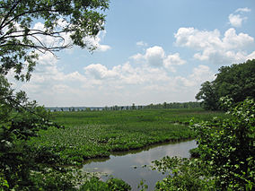
Elizabeth Hartwell Mason Neck National Wildlife Refuge is a National Wildlife Refuge of the United States located in Virginia. It is part of the Potomac River National Wildlife Refuge Complex. It is on Mason Neck, a peninsula in the Potomac River that forms part of the shoreline of Belmont Bay. The refuge is adjacent to Mason Neck State Park.
Established in 1969 and managed by the United States Fish and Wildlife Service, it was the first federal refuge created specifically for the protection of the bald eagle. It is 2,277 acres (9.21 km2) in size, with 4.4 miles (7.1 km) of shoreline. It is covered with oak and hickory forest and it includes the largest freshwater marsh in northern Virginia.
Since its founding, the refuge has been renamed for Elizabeth Hartwell, a local activist who fought to keep Mason Neck free of development.
Boardwalk in Mason Neck
![]() This article incorporates public domain material from websites or documents of the United States Fish and Wildlife Service.
This article incorporates public domain material from websites or documents of the United States Fish and Wildlife Service.
...
Wikipedia


