Elizabeth, West Virginia
| Elizabeth, West Virginia | |
|---|---|
| Town | |
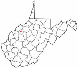
 Location of Elizabeth, West Virginia |
|
| Coordinates: 39°3′46″N 81°23′44″W / 39.06278°N 81.39556°WCoordinates: 39°3′46″N 81°23′44″W / 39.06278°N 81.39556°W | |
| Country | United States |
| State | West Virginia |
| County | Wirt |
| Area | |
| • Total | 0.53 sq mi (1.37 km2) |
| • Land | 0.47 sq mi (1.22 km2) |
| • Water | 0.06 sq mi (0.16 km2) |
| Elevation | 646 ft (197 m) |
| Population (2010) | |
| • Total | 823 |
| • Estimate (2012) | 838 |
| • Density | 1,751.1/sq mi (676.1/km2) |
| Time zone | Eastern (EST) (UTC-5) |
| • Summer (DST) | EDT (UTC-4) |
| ZIP code | 26143 |
| Area code(s) | 304 |
| FIPS code | 54-24364 |
| GNIS feature ID | 1538603 |
Elizabeth is a town in Wirt County, West Virginia along the Little Kanawha River. The population was 823 at the 2010 census. It is the county seat of Wirt County.
The site of Elizabeth was first settled by William Beauchamp (1743-1808) in 1796 when it was still part of the original, vast Harrison County, Virginia. It was known as "Beauchamp's Mills" until 1817 when it was renamed for Elizabeth (Woodyard) Beauchamp (1780-1838), the wife of William's son David Beauchamp (1776-1828). Elizabeth was chartered by the Virginia General Assembly in 1822 and became the county seat when Wirt County was created in 1848.
Elizabeth is located at 39°3′46″N 81°23′44″W / 39.06278°N 81.39556°W (39.062852, -81.395529).
According to the United States Census Bureau, the town has a total area of 0.53 square miles (1.37 km2), of which, 0.47 square miles (1.22 km2) is land and 0.06 square miles (0.16 km2) is water.
The climate in this area is characterized by hot, humid summers and generally cool winters. According to the Köppen Climate Classification system, Elizabeth has a humid continental climate, abbreviated "Cfa" on climate maps.
...
Wikipedia
