Electoral district of Unley
|
Unley South Australia—House of Assembly |
|
|---|---|

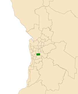
Electoral district of Unley (green) in the Greater Adelaide area
|
|
| State | South Australia |
| Created | 1938 |
| MP | David Pisoni |
| Party | Liberal Party of Australia (SA) |
| Namesake | Unley, South Australia |
| Electors | 24,450 (2014) |
| Area | 13 km2 (5.0 sq mi) |
| Demographic | Metropolitan |
| Coordinates | 34°57′5″S 138°37′0″E / 34.95139°S 138.61667°ECoordinates: 34°57′5″S 138°37′0″E / 34.95139°S 138.61667°E |
Unley is an electoral district of the House of Assembly in the Australian state of South Australia. Named after the suburb of the same name, it is the state's smallest electorate at just 13 km² (5 sq mi). It is an urban electorate in Adelaide's inner south, taking in the suburbs of Eastwood, Frewville, Fullarton, Glenside, Glenunga, Highgate, Hyde Park, Malvern, Myrtle Bank, Parkside, Unley, Unley Park as well as parts of Glen Osmond, Goodwood, Millswood and Wayville.
Unley was created as a conservative seat. It was first contested at the 1938 election, where it was held by conservatives until the 1962 election, when Gil Langley captured the seat for Labor. Unley was one of the seats that put Labor in government at the 1965 election after decades of the Playmander in opposition, with Labor managing to retain Unley in the close 1968 and 1975 elections and the 1979 election loss. Langley was succeeded by Labor's Kym Mayes at the 1982 election, a state government minister. In the close 1989 election Labor again managed to retain Unley. However, Labor was defeated at the 1993 election landslide by Liberal Mark Brindal. The electoral redistribution ahead of the 2002 election had a large effect on Unley, losing several suburbs west of Goodwood Road and gaining several suburbs east of Fullarton Road, changing Unley from a marginal seat to a fairly safe to safe Liberal seat in one stroke.
...
Wikipedia
