Electoral district of Reynell
|
Reynell South Australia—House of Assembly |
|
|---|---|

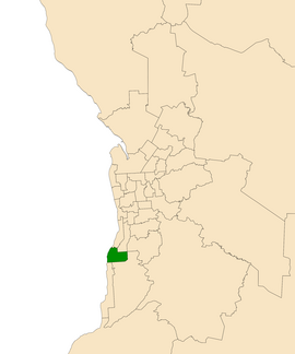
Electoral district of Reynell (green) in the Greater Adelaide area
|
|
| State | South Australia |
| Created | 1993 |
| MP | Katrine Hildyard |
| Party | Australian Labor Party (SA) |
| Namesake | John Reynell |
| Electors | 23,965 (2014) |
| Area | 30 km2 (11.6 sq mi) |
| Demographic | Metropolitan |
| Coordinates | 35°6′50″S 138°30′30″E / 35.11389°S 138.50833°ECoordinates: 35°6′50″S 138°30′30″E / 35.11389°S 138.50833°E |
Reynell is an electoral district of the House of Assembly in the Australian state of South Australia. It is named after John Reynell, a leading force in the founding of the Agricultural and Horticultural Society of South Australia and noted 19th-century grape farmer and vineyard owner in the area. Reynell is a 30 km² urban residential and industrial electorate in Adelaide's far south. It includes the suburbs of Christie Downs, Lonsdale, Morphett Vale and O'Sullivan Beach, as well as part of Christies Beach. The suburb of Reynella is currently in the marginal Liberal seat of Mitchell.
Reynell was created for the 1993 state election as a fairly safe Labor seat, but was won by Julie Greig for the Liberals as part of a statewide landslide. It was reclaimed for Labor at the 1997 election by Gay Thompson. Labor's Katrine Hildyard succeeded her at the 2014 election.
...
Wikipedia
