El Perelló
| El Perelló | |||
|---|---|---|---|
| Municipality | |||

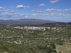
El Perelló with the Serra del Boix in the background
|
|||
|
|||
| Location in Catalonia | |||
| Coordinates: 40°52′36″N 0°42′47″E / 40.87667°N 0.71306°ECoordinates: 40°52′36″N 0°42′47″E / 40.87667°N 0.71306°E | |||
| Country |
|
||
| Community |
|
||
| Province | Tarragona | ||
| Comarca | Baix Ebre | ||
| Government | |||
| • Mayor | Ferran Cid Martí (2015) | ||
| Area | |||
| • Total | 100.7 km2 (38.9 sq mi) | ||
| Elevation | 142 m (466 ft) | ||
| Population (2014) | |||
| • Total | 3,155 | ||
| • Density | 31/km2 (81/sq mi) | ||
| Demonym(s) | Perellonenc, perellonenca | ||
| Website | www |
||
El Perelló is a municipality in the comarca of the Baix Ebre in Catalonia, Spain. It is situated in the north of the comarca, below the Boix and Cabrafeixet ranges. The N-340 road runs around the town, and connects it with the A-7 autopista at l'Ampolla.
The municipality of l'Ampolla formed part of el Perelló until 1990: their combined population as of 2007 is 2895. Populations below are for the territory of el Perelló as defined at the date given.
...
Wikipedia


